|
Bolivia
|
Lend a Helping Hand
You can help make the Virtual Classroom available to students by making a donation today.
|
| Origin of the name Bolivia |
Bolivia was named after of the Commander in Chief of the Liberation Army, Simon Bolívar. |
|
Symbols
|
Click on each link below to learn more about the symbols.
- Capital - La Paz
- National Animal - Llama
-
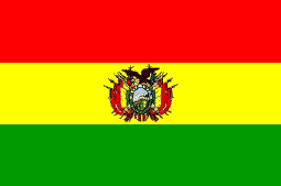
National Flag - Red is said to recall valor and green indicates fertility. The centered band of yellow symbolizes the country's mineral resources, and the coat of arms within that band is topped by a condor.
- National Anthem - Bolivianos,el hado propicio or Bolivians, A Favorable Destiny
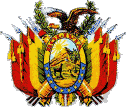
- Coat of Arms
- National Flower - The Kantuta Flower, or Cantua buxifolia, the Sacred Flower of the Incas.
- Independence Day - August 6, 1825
- National Motto - Morir antes que esclavos vivir
English: "To die before living as slaves"
|
|
Departments
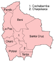
Bolivia has nine Departments
|
(Click on map to see it in detail)
Departments
Bolivia is divided into nine departments (Spanish: departamentos). These are, with their capitals indicated in parentheses:
- Beni (Trinidad)
- Chuquisaca (Sucre)
- Cochabamba (Cochabamba)
- La Paz (La Paz)
- Oruro (Oruro)
- Pando (Cobija)
- Potosí (Potosí)
- Santa Cruz (Santa Cruz)
- Tarija (Tarija)
Each department is further divided into provinces, or provincias, cantons, or cantones, and municipalities, or municipalidades, which handle local affairs.
Source: Wikipedia the free Encyclopedia,
|
|
Languages
|
Bolivia has three official languages: Spanish, Quechua and Aymara. |
| Bolivia History |
The history of the Republic of Bolivia reflects both its pre-Columbian and its colonial heritage. The ruins of Tiahuanaco testify to the first great Andean empire. Bolivians still speak the languages of the Aymara kingdoms and of their Quechua conquerors; the society remains predominantly Indian and rural, and only a minority is monolingual in Spanish. Nevertheless, Spain also left its imprint in the political, economic, and social spheres. During 300 years of colonial rule, Spain imposed its institutions on the colony and concentrated on mineral exports, which are still the backbone of the Bolivian economy. Using forced Indian labor, the Spanish extracted the mineral wealth--the silver deposits at Potosí were the largest in the Western world--and shipped it to Spain.
After Bolivia received independence from Spain in 1825, few of Bolivia's 192 governments have remained in power long enough to have much of an effect on the people.
Much has been written on the history of Bolivia. For more detailed information take a moment to review the essays posted on websites such as The US Library of Congress, Wikipedia, InfoPlease or Lonely Planet.
Source: US Library of Congress
|
|
Economy
|
Second most agricultural country in South America. Farming technology is mostly still primitive, and there is an underground economy based on contraband such as coca production. The exploitation of mineral resources, which accounts for nearly all the country's exports, and agriculture, which caters mainly to the local market, form the basis of Bolivia's economy. It is strongly influenced by fluctuations of demand and price of gas and tin on the world market. Most of the country is under-developed and poverty is widespread, especially among the rural and mining populations.
|
|
Geography and Climate
|
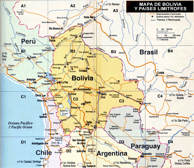
Landlocked Bolivia sits astride the Andes in the west-central part of the South American continent. With an area of 1,098,581 square kilometers, the country is about the size of Texas and California combined, or twice the size of Spain. Bolivia has 6,083 kilometers of land boundaries, which adjoin five countries. The country is bounded by Brazil to the north and east, Paraguay to the southeast, Argentina to the south, Chile to the southwest, and Peru to the northwest
In general the climates in Bolivia are dictated mostly by altitude not latitude. There are basically five separate climatic regions: The Andes and Altiplano, the Yungas and Chapare, the temperate valleys, the Chaco and the tropical lowlands of the upper Amazon basin.
Andes and Altiplano:
In the highland region, located in the western third of the country, the weather does not change too dramatically from season to season. In general it's a cold weather region. The mountains rise to over 21,300 ft and average between 17,000 and 19,000 ft.
The Altiplano:
Altiplano means high plain but in reality it's not very flat and is made up of valleys, small hills and rolling areas as well as salt flats, volcanoes, rivers and lakes. It is generally cold and windy and mostly treeless. The vegetation is sparse and mostly made of tough clumps of grass called ‘ichu', short and tough Thola bushes and ocassional stands of native trees called Quenua. It has the world's biggest salt flat (Salar de Uyuni) and various others as well as Red and Green lagoons in the south.
The Yungas and Chapare:
The Yungas and Chapare regions are the eastern side of the Andes that are between the high Andes mountains and the upper Amazon basin. The geography for the most part is steep and rugged with a lot of jungle and whitewater rivers, which are abundant. This region is generally hot and humid.
The Temperate Valleys:
These valleys are generally concentrated in the central and south-central part of the country have some of the most pleasant climates in the country. The geographic variety of the rolling hills and temperate climate made this region a favorite for the Spaniards during the colonial era. They characteristically don't have the extremes temperature changes that occur daily or seasonally in other regions. The climate is mild and mediterranean-like. This region is where the majority of the fruits and vegetables come from and which are distributed country-wide.
The Chaco Scrub and Plains:
In general the Chaco is known as the desert of Bolivia. It is generally flat with some rolling hills and valleys and a few rivers that drain the sparse landscape. Since it's so inhospitable few people live here and so the abundance of wildlife is varied and abundand.
The Tropical Lowlands:
These regions, which make up most of the Bolivian territory are composed of the upper Amazon basin in the north and northeast regions and the Parana basin in the east and south-east region. These tropical lowlands have a variety of ecosystems and in general they are hot and humid year round.
Source: ExploreBolivia.com
WEATHER
What is the weather like in the Region today? Follow this link to The Weather Underground for the forecast for the cities visited by our explorers. Or check out this satellite map from Weather.com.
Try converting the temperature in your town from Fahrenheit to Celsius.
TIME
Most of South America is in the same time zone. What time is it in different cities in the region as compared to the time in your home town? Check this!
|
| Population, Ethnic Groups, Culture and Religion |
POPULATION
Bolivia's principal groups were a small number of whites, a larger, more fluid and diverse group of mestizos, and a majority of Quechua or Aymara Indians.
Mestizos and cholos, technically those of Spanish and Indian descent, constituted 25 to 30 percent of the population. Geographically, this was the most widely distributed of ethnic groups; economically and socially
RELIGION
Roughly 95 percent of Bolivians consider themselves Roman Catholics, nonetheless, a much smaller portion participated actively. Roman Catholicism had its roots in the Spanish conquest; priests accompanied the first military expeditions.
Because of the church's weak rural presence, the vast majority of Indians followed their own brand of folk-Catholicism far removed from orthodoxy. Indians saw no inconsistency in mixing modern technology and medicine with folk curers or indigenous ritual with professed Roman Catholicism. Indigenous rituals and fragments of Roman Catholic worship were interwoven in the elaborate fiestas that were the focus of social life.
The Quechua and Aymara pantheon was a mix of Christian and preconquest spirits and beings. A deity like the virginal daughter of the Inca sun god was transmuted into a Christian figure, in this case the Virgin Mary. Many of the supernaturals were linked to a specific place, such as lake and mountain spirits. The earth mother, Pachamama, and fertility rituals played a prominent role.
CULTURE
Language served a major role in shaping ethnic identification and relations. Traditionally, the inability to speak Spanish had contributed to the vulnerability of the Indians. Mestizos and whites controlled access to the larger society through their command of Spanish. Until the latter part of the twentieth century, only minute numbers of Quechua and Aymara were bilingual; for many of these, competence in Spanish was simply a step in severing their links to their Indian identity.
|
| Fauna and Flora |
Flora
Bolivia shares much of the wide variety of flora and fauna found in the four countries surrounding it. Because of the wide range in altitude, Bolivia has plants representative of every climatic zone, from arctic growth high in the sierra to tropical forests in the Amazon basin.
Fauna
On the Altiplano, the most important animal is the llama, one of the most efficient carrier animals known; alpaca and guanaco and several varieties of cavy (guinea pig) are found there, too. Lake Titicaca has several varieties of edible fish. In the tropical Amazon region are the puma, coati, tapir, armadillo, sloth, peccary, capiguara (river hog), and ant bear, as well as several kinds of monkeys. Birdlife is rich and varied. Reptiles and an enormous variety of insects are found below 3,050 m (10,000 ft).
Source: NationsEncyclopedia.com
|
| Environment |
The chief environmental problem in the densely populated Altiplano is soil erosion, resulting from poor cultivation methods (including slash-and-burn agriculture) and overgrazing. Erosion currently affects 30% of the land in Bolivia. Salinity and alkalinization are also a significant problem. Inadequate sanitation and solid-waste disposal, as well as effluents from mining activities, contribute to the Altiplano's declining water quality, which poses a threat both to fish life and to human health. Bolivians have 316 cu km of renewable water resources, but only 95% of the city dwellers and 64% of all rural people have pure water. The main sources of water pollution are fertilizers, pesticides, and mining.
Source: NationsEncyclopedia.com
|
Sources: Wikipedia the free Encyclopedia, InfoPlease.com, Government of Argentina, Moon Handbooks Argentina by Wayne Bernhardson 2005, www.argentinaonview.com/english/argentina.htm, www.infoplease.com/ipa/A0107288.html, Lonely Planet Publications Argentina, www.argentinaonview.com, www.Argentinaturistica.com
Kim and Don Greene, Contributors; publication date April 6, 2006
|