Baja Norté
February 24
February 25
February 26
February 27 - 28
Spending the day in Guerrero Negro we decided to explore the large salt works complex that borders the town. We drove off toward Laguna Guerrero Negro and the abandoned workings at the old salt pier.
The road cuts through a salt marsh where we were treated to close up views of herons, egrets and loons. We also spied a number of ospreys sitting in their nests atop platforms built on utility poles. The salt marsh is an important stop on the migratory bird route. The migratory birds eat grass, roots, bulbs, grain, seeds, crustaceans and insects, all supplied by the marsh. Geese and ducks eat the sea weeds and a plant called Sea Lavender collects mud and sediments so that there is always more earth for new plants to grow.
From the old salt pier we had a fabulous view of the sand dunes on an island called Isla Arena (sand island). The sand dunes here and north of town can reach 26 feet (8 meters) in height.
Next stop was the newer salt shipping facilities at Puerto El Chaparrito. The local salt works, operated by Exportadora Sal, works a system of diked ponds exceeding 70 square miles in size. Seawater is pumped into the ponds then left to evaporate until it turns into thick layers of salt (See salt pond photos). The salt is then scooped up and taken to Puerto El Chaparrito for shipment.
| Driving through the salt ponds we discovered that many ponds were of different colors. Some were pink or green, others were blue or red. As the sea water evaporates, the different levels of salinity support different algae and other organisms that can live in these ponds. | 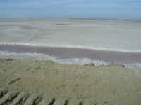 |
At the port we viewed salt being loaded onto barges from a huge mound of sea salt. The mound dwarfed our vehicle. We found that the sea salt formed large beautiful crystals.
We then drove to the opposite side of town, through more miles of salt evaporation ponds so that we could set up camp on the shore of Laguna Ojo de Liebre (Scammon's Lagoon). For more information on the history of the lagoon, check out the whale information on the Baja home page.
As the sun went down, we were treated to a magnificent display of whale acrobatics as we saw spyhoppings, tails and many full breechings - all from shore thanks to our Bushnell Perma Focus binoculars.
Latest government statistics indicate that as of February 20th, there were 1,169 Gray Whales in this lagoon, including over 460 babies.
What a great way to start the day. Coffee on a beach watching whales playing just offshore!
After a couple of hours we had to say a final farewell to the whales and resume our trek to the U.S.
Tonight's goal was the magical area of Cataviña. We stopped here nearly four weeks ago and fell in love with the rock gardens of giant granite boulders, boojums, cardons and cactus.
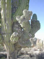
Today's camp was just as great. As we hiked around we found two very interesting cardons. The first one had a rare deformity that we had only seen on a few saguaro cactus in the American Southwest.
|
|
The deformity causes the arms to grow in a flowery shape referred to as a "Cristos" cardon. |
The other cardon showed us an example of the strength of mother nature. The trunk of this cardon had exploded, either from a lightning strike or from being hit with a whirlwind (small tornado).
| The arms of the cardon were lying on the ground in three different directions. When we measured their length, we found that when the cardon was alive it stood over 50 feet tall. How magnificent and awesome. | 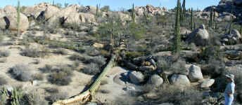 |
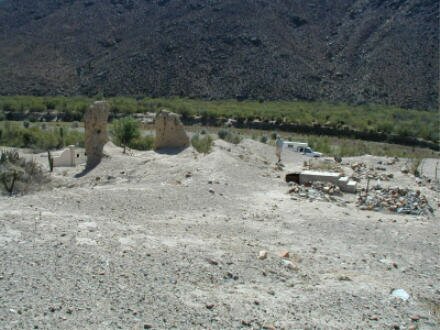
First stop 1768/69, the Misión San Fernando Velicatá. The ruins here are of the only mission in Baja California that was established by the Franciscans, and more interestingly, by Father Junipero Sierra.
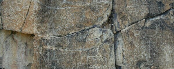
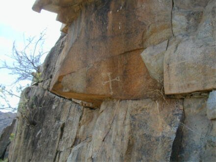
| Prior to the arrival of the missionaries, Indians lived here as evidenced by the existence of the many petroglyphs etched in the boulders near the mission ruins. |
|
The mission itself flourished for about 60 years until an epidemic killed nearly all of the Indian population. BY 1822 the mission was closed.
| The only evidence of the mission left for us to explore were two corners of the church and the remains of an aqueduct used to transport water to the fields. |
|
|
|
Immediately above the aqueduct we discovered the remaining petroglyphs. Some date back 1000 years, some only to the time of the mission. |
Next stop 1890 and the town of San Quintin. In that year an English company, Lower California Development, established a harbor, built a flour mill and started construction of a railroad to Enseñada. The investment soon failed due to drought that ruined the wheat planting.
Tomorrow we will visit the remains of the attempt, the old mill, old pier and the English cemetery.
Bahiá San Quintin is one of the major geological features of Baja's pacific coast. There are five volcanic craters that mark its location. A sixth crater is the Island of San Martin just off the coast. There are shallow tidal flats that cover most of the bay and which assist many birds in their annual migrations.
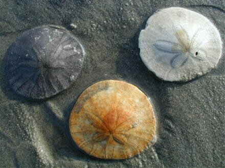
We made camp on the beach at the edge of the bay. When we walked out on the beach, we were amazed to find not only a row of sand dunes, but on the beach itself, we found so many sand dollars that even if we were so inclined, we could never pick up too many.
| It seems like there were tens of thousands of sand dollars lying in the surf. |
|
As we explored San Quintin, we wandered over miles of sandy back roads in search of the remains of the 19th Century English development. We finally found the "old English Cemetery" located on a beautiful point of land reaching into the bay. However, other than finding a few more recent graves with English surnames, we did not find any evidence of older tombs. Many of the graves were marked with old wooden crosses upon which the names had been erased by the passage of time.
Not much remains of the old pier. We found a long stretch of pilings that extended into the bay and they are all that's left, together with a nearby rock retaining wall marking the edge of the harbor. Take a look at the panorama photo of the bay overlooking the old pier.
About two miles away we found the old milling equipment standing in the garden of a motel. It seemed that the milling equipment was still anchored in the old concrete and the motel had been built around it.
After having a wonderful lunch at a small restaurant on the highway, we climbed back in our expedition vehicle and drove up to La Bufadora with hopes of witnessing the explosion of water from the La Bufadora Blowhole.
| As waves rush up to the cliff face, water gets forced into an underground cavern with such force that water blows out of a hole in the top of the cavern sending a plume of water high into the air. While we watched, we were able to see this great sight. |

|
Although the plumes didn't reach their maximum possible height of nearly 100 feet (30+ mts), it did splash about 50 feet high. Very fun. We even took a short video of the blow.
We then found a secluded spot on Punta Banda to set up our final camp of the expedition. Believe it or not, as we looked out at the ocean, we could see spouts of water from some California Gray Whales as they made their way back north to Alaska.
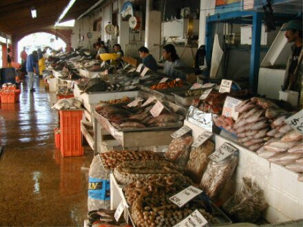
The next morning, our last in Baja California, we made a stop at the famous Ensenada Mercado de Mariscos (Seafood Market) to watch the fishermen unload their catch and set up their stalls to sell it.
|
|
The stalls had nearly everything that swam or lived in the local waters for sale. After viewing the assorted fish, squid, octopus and shellfish, we purchased a dozen large chocolaté clams to cook up later for dinner. |
With our cooler full, we headed north for our inspection at the Tecate USA/Mexico border. Less than two hours later, we were waived through immigration with nothing more than a cursory search and we ended the Baja California Expedition as we re-entered the U.S. Our total mileage round trip from our base in Arizona was 3,587 miles!