April 4, 2005
Today we headed down to the beach. We'd heard of a nice relaxing spot on the Pacific coastline called San Juan del Sur. The town played a part in the California gold rush in the mid 19th century. Cornelius Vanderbilt brought potential prospectors from the eastern US ports up the Rio San Juan to Lago de Nicaragua, then across the 20km of land by stagecoach to the port of San Juan del Sur where ships would then transport them to San Francisco, California. This option was considered to be quicker and more comfortable than traveling across the United States by land.
On the way we could look out to the Isla de Ometepe, an island in Lago de Nicaragua. The island was formed by two volcanoes. When we looked out, we got a big surprise, we could see steam rising from the larger of the two, Volcán Concepción. It wasn't erupting but it was sure being active.
Consulting our map, we found what looked like a back way to the beaches north of San Juan del Sur that looked promising. We decided to give it a try. The first part was actually paved and we thought we'd hit the jackpot. However the pavement soon ended and we struck out across the hills on dirt roads. The signage was poor so we keep stopping to ask locals the way to the beach. Well, you ask three people, and you get three different answers. So after an hour of driving this way and that, we gave up and drove back to the highway and took the main road. Well it was a good idea as we later found out, because we'd probably have missed the turn off to our destination, Playa Majagual, as it too was poorly marked. But we did make it to the beach, arriving just as the sun went down.
April 5-6, 2005
These two days were just a break from traveling around. We find that every now and then we really have to take a couple of days off from driving and negotiating the roads and towns along the way. Even though we drive slowly and we try not to travel long distances, just being on the roads and dodging ox-carts, bicycles, motorcycle rickshaws, buses, trucks, horses, pedestrians and - well you probably get the picture - just wears us down.
So the RX is finding a nice peaceful place to recharge. We were able to set up our new hammocks, pull out a couple of books to read and just relax. We did manage to pry ourselves from our hammocks long enough to take walks on the beach and to go swimming. The only thing irksome was that the wind, which keeps the temperature cooler and the bugs at bay, was also blowing fine sand onto everything.
April 7
We got an early start as today was a border crossing day. As has been our routine, we like to arrive at the border shortly after they open. When we arrived, we found that the local municipality required us to pay one dollar each just for the privilege of driving through their town to the border. OK, we paid that and drove into the border control area. We immediately had "assistants" running up to the Fuso, trying to jump up on our steps to have us hire them to help us through the border procedure. We said thank you but no, we're able to do this ourselves.
Upon parking, an official came over to write down our vehicle information on a slip that would have to be stamped by other officials, then surrendered to another official as we actually crossed the border. OK. We went into customs to clear our vehicle and were the only ones exiting Nicaragua at the time. So we just breezed through the paper work. Then we had to stand in line behind people coming into the country as there was only one immigration officer to stamp the passports.
Thinking this was strange, since after all, there were several buses full of passengers arriving and departing, Don went off in search of where the bus passengers were getting their passports stamped. After finding that office and asking if we could get our passports stamped there, we left the other line, got our stamps and got out of Nicaragua. Really it was pretty easy, and there were no "fees" to leave the country.
Arriving at the Costa Rican side, we had to pay about $4.50us to have the exterior of our vehicle fumigated, then we drove to the immigration office. We parked and went inside and got our entrance stamps in all of a couple of minutes. Then we walked to the vehicle permit window (next window down) to get our temporary import permit. We had all but one of the necessary copies of documents, but hey, there's a copy machine just next door. Then it's outside to the customs office where we have to explain "It's not a truck, its a camper", get a brief inspection and paperwork to take back to the vehicle permit window.
Meanwhile, we're concerned about how we're going to be able to leave the country in a few weeks to fly back to Arizona at the end of this expedition and leave the Fuso in Costa Rica. Generally we get the vehicle permit stamped into one of our passports. This is to guarantee that we don't sell the vehicle or leave it in the country without paying import taxes. Each of the countries we've traveled to on this expedition have given us this stamp. Well we go back to finish our permit and to try and talk the inspector into NOT stamping the permit in our passport. No problem, we didn't even have to ask. We don't know if he forgot or what, but he gave us our permit and didn't stamp either passport. So our only concern now is to find a place to store the Fuso until we return to explore Panama and onto South America.
We drove on for a couple of hours, dodging incredible potholes while getting our first views of the scenery in the Guanacaste region of Costa Rica. We made camp in the parking area of a balneario just outside of Canas - and we got to use their swimming pool too. The people in Central America are very big on balnearios (swimming hole or pool, usually with a restaurant and sometimes camping or a hotel) and we have found them throughout the region. Its a great way for families to party and relax on holidays and weekends.
April 8, 2005
It's time to leave behind the hot, dry weather of the lowlands behind. Today we drove up over the Cordillera de Tilarán to Lago Arenal. We climbed nearly 2,000 feet in elevation sometimes moving along at a snail's pace. We read about a local nursery that grows orchids, cactus and other tropical plants that we could walk around to view the flora. The owner was very friendly and talked with us for a while. She used to have a butterfly garden but found it too much work in addition to her plants. We were disappointed not to see the butterflies, but we really enjoyed seeing several varieties of orchids that were blooming. One of the plants had a series of flowers that looked like flying dragons!

After lunch we drove along the lake shore not really knowing how far we might drive. The lake started out as a small lagoon, then in 1973 Costa Rica built a dam at the eastern end of the valley to create the 32km long lake we see today. The lake was built to provide hydro-electric power. The dam flooded out the village of Arenal, but a new town was built for the displaced landowners. We drove to Nuevo Arenal and found a great campsite in a park on the shoreline. We had read about a rare annular eclipse that would occur this evening but at the appointed time our view was totally obscured by clouds. However, the sky did get very dark and the birds all came out thinking that it was dusk, but it was only 4pm.
April 9, 2005
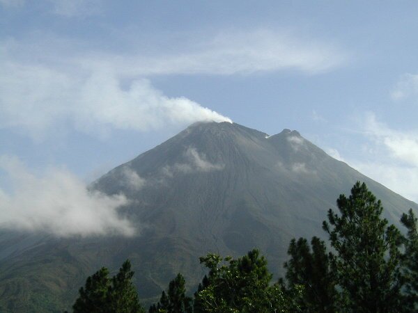
| Driving the last part of the road around the lake we finally got our first view of the massive Arenal Volcano, considered to be one of the world's most active volcanoes. Although the top of the mountain was in the clouds, when we looked through our binoculars we could see boulders of lava rolling down the mountain sides sending up puffs of ash and smoke. Very cool. |
|
We stopped behind the dam where a series of walking bridges have been built in the jungle, some spanning ravines, waterfalls and treetops. We hiked the 3km trail for nearly 3 hours, stopping frequently to look for birds, insects and wildlife. Like most days, we weren't sure about where we would camp for the night, but we knew we wanted to be somewhere that had a view of the volcano. We headed to Arenal Observatory Lodge to see if it was possible to spend the night in their parking lot. We were charged about $3us each to enter their property and we found a nice spot where we were out of the way and decided it was good enough to spend the night. We even got to enjoy watching the volcano from the lodge's observation deck. And watch we did. For hours we watched and listened to lava rocks rolling down the volcano, and after it got dark, we watched as the boulders exploded into bright red showers of sparks. Just before sunset the volcano made a very audible huffing and puffing sound and we saw a mini eruption and plume from the main crater.
April 10, 2005
We got up this morning and immediately headed to the viewpoint to watch the volcano. Again we were not disappointed especially since the top of the volcano was clear of clouds and we could plainly see the steam rising out of the crater.
Later in the morning, we hiked through trees across the outskirts of the volcano to the lava flow from 1992. Along the way we could hear the rocks rolling down the sides and it was rather disconcerting because, even though we knew the volcano was a long way away, the trees obscured it and the sound made it seem very close. The location of the lava flow brought us the closest we were able to safely get to the volcano. We were directly below the rock fall area and about a 1/2 mile from the base. It was a very exciting experience.
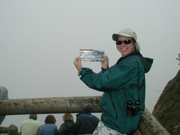
After our hike, we set off to visit another volcano, Volcan Poas. The drive took us up the slopes of the volcano and through beautiful countryside where coffee was being grown on the lower elevations, strawberries higher up and close to the top, dairy farming was the most common. Also as we got higher in elevation, the weather started to deteriorate. First it started raining off and on and then periods of fog would descend.
And just when you think it can't get any worse, just as we were coming to the last intersection before the turnoff to the volcano park, we came over a hill and a truck was stopped at a strange angle, blocking both our lane and most of the other lane. Small cars and trucks were able to squeeze around the side, but since we don't qualify as a small truck, we decided not to risk slipping off the wet grass into the gully on the far side. So we 5-point turned around on the narrow road and headed back the way we came to find an alternative route. Following the map and a note in our guidebook about distances, we decided to chance a dirt road to get around. Suffice it to say, alls well that ends well, but it was a really lousy dirt road and the distances in the guidebook were incorrect.
Anyway, eventually we ended up on the highway where we needed to be, but now we'd lost a couple of hours drive time and darkness was quickly approaching, not to mention again the rain and fog. And the narrow, winding mountain road. As the visibility became almost nil and we realized we still had a long way to go before the expected hotel parking lot would materialize, we chanced upon a small store with a large parking lot off the side of the mountain. Which was actually a miracle because we hadn't seen anything with a big enough parking area anywhere on the mountain. Quickly pulling over (and letting the line of cars behind us go by) we decided that it was the perfect place to spend the night, providing it was OK with the owner. The owner had absolutely no problem with us spending the night there and we added another first to our camping experiences: just parking on the side of the highway.
April 11, 2005
When we got up this morning we found another nice thing about our fancy campsite on the side of the highway. An absolutely gorgeous view. The clouds cleared for a short while and the view down into the central valley of the country was just spectacular. On this note we continued up the mountain to Poas. But the weather changes quickly and we were constantly going in and out of clouds and fog as we wound our way up. Along the way we also passed a very spectacular waterfall, right off the side of the road, "Catarata de Paz" which means "waterfall of peace".
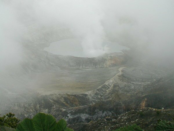
Finally we broke through the clouds and once again we were treated not only to the spectacular view but the high hopes of being able to get a good view of the crater lake in the top of the volcano. Few volcanos allow you to drive all the way to the rim but Poas lets you get to the very edge of one of the world's largest active craters (1.5km wide). Looking down from the viewing platform, you can see Poas' bubbling sulphuric pool and fumeroles. That is if it is clear. Typically the only time it is clear, is first thing in the morning, in the dry season. OK, it's 8:30am, it's the dry season, why is the crater fog filled? It was the strangest phenomenon. One side of the volcano was completely clear, while the other side was completely fogged in.
We decided we had nothing better to do than wait and see it the fog would lift. We waited for about half an hour with no changes and decided to check out some of the hiking trails. Just as we got to one, the sky seemed to clear and get brighter. Hurrying back to the rim, we were treated to a clearing of the fog just enough to see the blue/green pool at the bottom of the crater and steam generated by the fumeroles. It wasn't the greatest view, but it was nice to see the crater after all we had gone through to get there. The view only lasted a few minutes before the clouds returned to blot it out again.
|
|
|
Driving back down off the volcano was just as exciting as the drive up except on the way down there was a bicycle race coming up! We couldn't believe that in the fog and rain, on a narrow, winding, mountain road with no lane closures or anything, there were bicycles coming at us on both sides! The only thing we could do was go really slowly and try to avoid hitting anyone. We couldn't believe the risk they were taking.
April 12, 2005
We spent last night outside of San Jose, the capital of Costa Rica in the only trailer park in the country. This will be our last update until we return to Costa Rica in July. Thank you all for joining the team. We have enjoyed your comments and emails. In July we continue south through Costa Rica and Panama, then find passage to South America.