|
January 7 - 13, 2005 - Ushuaia
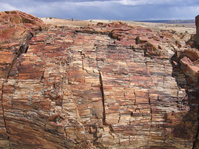
In the morning we ran some errands (you know, we always have to do stuff like shop and do internet, just like at home) and then we hit the road. We finally saw our first lesser Rhea after weeks of looking. It was a female and she was surrounded by 18 little Rheas! (flightless birds like the ostrich) Our destination for today was the Monumento Natural Bosques Petrificados or Petrified Forest. This 13,700 hectare park is littered with fossil tree trunks left behind after a massisve volcanic eruption during the Jurassic period. The eruption flattened them and covered them with ash, turning them to stone. Today the area appears as a painted desert, a barren wasteland with these huge colorful trunks lying above, beneath and poking up out of the ground.
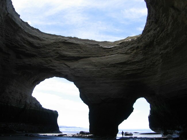
After wandering the trail in the park, we headed out looking for a spot to camp for the night. Off of the dirt road we drove in on, we found a spur that headed toward some hills. Off the spur we found a depression that would shelter us some from the constantly blowing wind. After getting ourselves set, we headed off for a hike. There were lots of pieces of petrified wood and pretty stones and bones of long dead animals to explore. We were so engrossed in what we were doing, that we didn't notice that the wind had died. All of a sudden we noticed the absolute silence. No wind, no traffic noise, no nothing. It was absolutely silent and it seemed as if we had the world to ourselves. The next morning it was still beautiful and we took another hike. This time we saw guanacos that were pretty close to our camp. That was pretty cool. Of course, they moved away as soon as we tried to get close. Today was an all day drive with our destination the Parque Nacional Monte Leon. Along the way, we stopped in the city of Puerto San Julian. This historic city and safe harbor is the site where in 1520, Magellan spent the winter during his year of circumnavigating the world. The city boasts a reconstruction of the La Victoria, Magellan's ship. The ship was small and must have carried a number of crew to keep her running. No wonder Magellan had to put down a mutiny here. Late in the afternoon we arrived at the National Park. This land was purchased by environmental philanthropists Doug Tompkins and Kris McDivitt and donated to the Argentine government to be used as a park. It is only the second coastal park in Argentina, after Tierra del Fuego. The area hosts lots of life including guanacos, penguins and sea lions. The coastline is spectacular, with lots of interesting formations and caves.
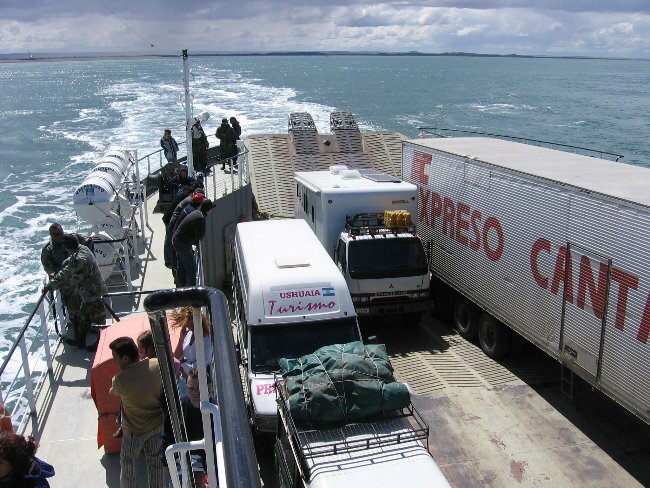
After spending half a day at Monte Leon, we headed off for a couple of hours drive to the town of Rio Gallegos. This town is known for its windiness and all over the town you can see huge wind fences that have been erected to create some shelter. At the campground where we stayed, the owners had erected not only fences, but planted lots of trees to act as wind breaks. It was a very attractive place and the wind breaks created a pleasant place. We are finding that the wind is a constant companion. It doesn't affect us too much, but some days driving in it makes for a very tiring day. The next morning we were off to cross the border into the little slice of southern Patagonia that is Chilean territory. The island at the bottom of South America is called Tierra del Fuego and it is split in half between Chile and Argentina. So we have to cross out of Argentina and into Chile and then cross back out of Chile and into Argentina. Arriving at the border, we were dismayed to see a huge line of people waiting to cross. Apparently our timing was bad as in addition to the crush of vacationers with their own cars, there was a busload of people. Everyone had to be stamped out and it took about and hour and a half. Crossing into Chile took about 15 minutes. After finally finishing up, we headed toward the ferry crossing that would take us across the Straits of Magellan and onto the island of Tierra del Fuego, the end of South America.
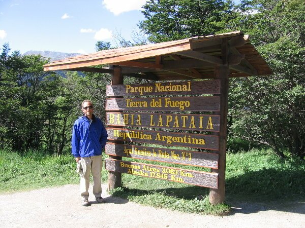
Up till this point, all the dirt roads we have taken have been to make side trips. None of the roads have been major transportation links. That changed in Chile. For the first time, we took a major road that was unpaved. I wish I could say that since it was a major road it was well cared for, but it was in poor shape and we averaged about fifteen miles per hour. Fortunately, the unpaved segment was only 60 miles long, but at that rate it took us four hours. We spent the night in a restaurant parking lot, before crossing back into Argentina the next morning. The morning's border crossing went much smoother and took about 15 minutes, the way it should. Crossing back into Argentina, we once again had a paved road. We traveled along the coast for a while, watching the same scenery that we had been seeing for days, which was open steppe with grasses. All of a sudden we began seeing trees! And hills! And a huge lake! This was a very enjoyable change and signaled that were truly approaching the "end of the world". The road to Ushuaia, the southern most city in the world, used to be entirely gravel. In the past few years the government has been working to get it paved, and we only had a gravel section of about 25 miles to travel. Just as we were approaching the end of the gravel, we had a crazy driver approach from the other direction and start to lose control of his car. Fortunately, he missed us and regained control, unfortunately for us his tires kicked up a rock that smashed into our windshield leaving a large smashed area. The rock hasn't sent cracks spidering across the windshield, yet, but we have to try to find a shop that can repair it before it gets worse. A few miles later we reached our southern goal, Ushuaia. We'll stay here a few days to explore the Beagle Channel, the glaciers and the national park. We were able to set up camp at a ski resort that has a great view overlooking the city. All around we had fabulous views of craggy mountain peaks, glaciers and the Beagle Channel (named after the ship that carried Charles Darwin on his journey of discovery). In the morning we explored Ushuaia, walking along the main drag and the waterfront. After so much time on the road, it was really weird to find a city full of tourists. Being the southernmost city in the world means that this is a destination for travelers from around the world. Now add to that a cruise ship full of passengers, and you don't feel that you've just driven 20,000 miles to get here! After a couple of hours wandering, we drove up to the trailhead to the Martial Glacier. It is located above the city, up above another ski resort. So we were able to ride a chairlift about half way up the mountain, then hiked up above the tree line, across the glacial moraine and close to the glacier itself. Having retreated in recent years, the glacier can be reached, but up a dangerously steep and slippery slope. We chose not to take the risk.
|