![]()
GHANA
Expedition Journal
Photographs
Origins
Symbols
Regions
Languages
History
Government
Economy
Geography and Climate
Population, Ethnic Groups, Culture and Religion
Fauna and Flora
Environment
Resource Links
Lesson Plans
Check out the Route Maps
Send us an Email
Camping Information
|
Expedition |
|
Lend a Helping Hand You can help make the Virtual Classroom available to students by making a donation today. |
| World of Wonders Project: The West Africa Expedition |
|
Ghana
|
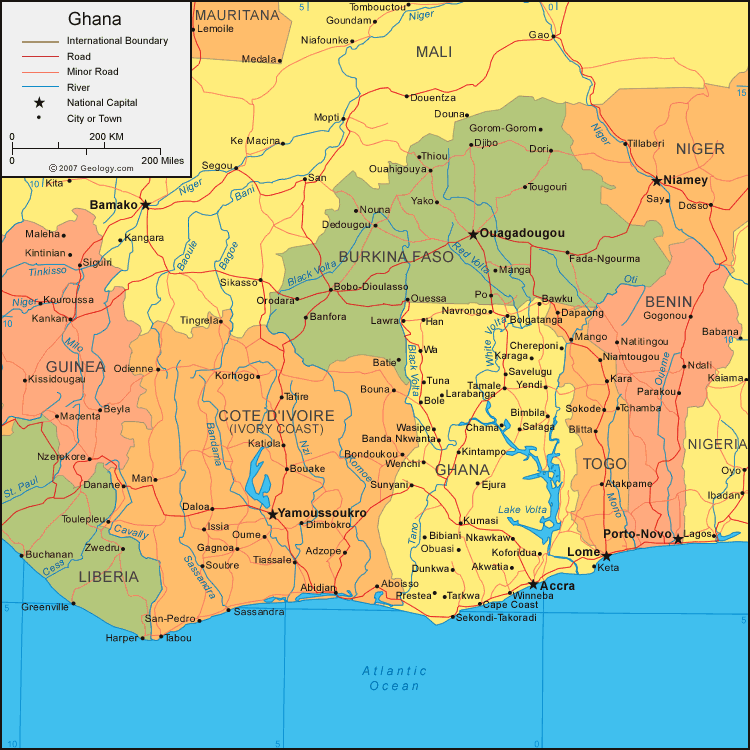
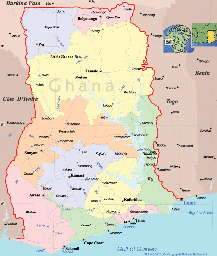
Click on either map to see it in detail
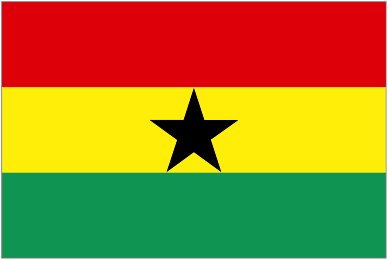
| Origin of the name Ghana | Official name is Republic of Ghana. The country is named after the Medieval Empire of Ghana to symbolize its historic place as the first black African nation to gain political independence from European colonial rule. Ghana was formerly a British colony known as the Gold Coast. | ||||
|
Symbols
|
Click on each link below to learn more about the symbols.
|
||||
|
Regions
|

|
||||
| Language |
Official language is English. More than 250 languages and dialects are spoken in Ghana. Native Ghanaian languages are divided into two linguistic subfamilies of the Niger-Congo language family. Tamale Languages belonging to the Kwa subfamily are found predominantly to the south of the Volta River, while those belonging to the Gur subfamily are found predominantly to the north. The Kwa group, which is spoken by about 75% of the country's population, includes the Akan, Ga-Dangme, and Ewe languages. The Gur group includes the Gurma, Grusi, and Dagbani languages.
Nine languages have the status of government-sponsored languages: Akan, Dagaare/Wale, Dagbani, Dangme, Ewe, Ga, Gonja, Kasem, and Nzema. Though not an official language, Hausa is the lingua-franca spoken among Ghana's Muslims, who comprise about 14% of the population. Source: Wikipedia |
||||
|
History
|
History
There is no evidence that any of the powerful kingdoms that dominated the Upper Niger River ever dominated the area that is now Ghana. However, upheaval in the kingdoms contributed to population migrations into the region. Muslim traders influenced the affairs of northern peoples such as the Gonja and Dagomba, most significantly was their introduction of Islam. The second half of the 15th century when the first Europeans arrived in the area, the ancestors of most of today’s ethnic groups were already established in the present territories. In this period, the various groups began organizing into states. Over the years, trade contacts with the Islamic states of the north and, later, with the Europeans on the coast contributed to the rise and fall of these local states. The Ga people of the coastal plains organized into an effective political unit in approximately 1500. Islamic trade networks stimulated the development of Akan states, and the Akan-speaking Denkyira people of the southwest rose to become a dominant power by the 1650s. In the northern regions of the country, the Gonja, Dagomba, and Mamprusi contested for political power in the 1620s. However, it was the Ashanti Kingdom, located in south central Ghana, that was the most influential. By 1820 Ashanti held some degree of military and political influence over all of its neighbors. The British-Ashanti Wars The Ashanti saw British interference in its conquered territories as infringement on its sovereignty and fought back. During a confrontation in 1824, the Ashanti army routed a British force and killed its commander the colonial governor of Sierra Leone. In 1826 the Ashanti launched an offensive against British coastal positions butvwere turned back by an alliance of British and Danish troops in a fierce battle on the plains near Accra. The Ashanti signed a peace treaty with Britain in 1831. Colonialism and Independence In the early 20th century, nationalists challenged the arbitrary nature of the colonial political system, which placed unlimited power in the hands of the governor and his appointed Legislative Council. Demands on the colonial government intensified after World War II.
A new constitution was adopted in 1951, replacing the Legislative Council with a Legislative Assembly, designed to provide rural Africans greater representation. Following intense constitutional negotiations and a hotly contested election, the CPP emerged on March 6, 1957, to lead the government of an independent Ghana. Source: "Ghana," Microsoft® Encarta® Online Encyclopedia 2008 |
||||
| Government |
Government
Ghana's constitution was adopted in 1992. Ghana is a multiparty democracy and all citizens aged 18 and older are entitled to vote. The country is divided into ten administrative regions: Ashanti, Brong-Ahafo, Central, Eastern, Greater Accra, Northern, Upper East, Upper West, Volta, and Western. Each region is led by a regional executive, who is appointed by the president. Below the regional level are district assemblies. Some district assembly members are appointed by the central government, but the majority are democratically elected. Source: "Ghana," Microsoft® Encarta® Online Encyclopedia 2008 |
||||
| Economy |
Economy
Agriculture, forestry, and fishing form the traditional backbone of Ghana’s economy. Cattle are raised in the dry savanna regions of the north and in the plains region around Accra. Bananas, plantains, rice, corn, and cassava are produced as food crops in the southern half of the country. In the drier north, the major crops are yams, sorghum, and millet. The wet forest zones allow the cultivation of cash crops such as cacao, coffee, and palms and the harvesting of tropical timber. Freshwater fish are available in the rivers and Lake Volta, but the Atlantic Ocean provides the bulk of the nation’s fish supply. The service sector accounted for 39.4 percent of GDP in 2005.
Ghana remains heavily dependent on foreign aid.
WEIGHTS AND MEASURES: Metric weights and measures are used.
The Ghanaian unit of currency is the new cedi, divided into 100 pesewas (.89 Cedis equal U.S.$1; 2008 average). Source: "Ghana," Microsoft® Encarta® Online Encyclopedia 2008 |
||||
| Geography and Climate |
Geography Ghana is located on the Gulf of Guinea along the west coast of Africa. It is bound by the Ivory Coast to the west, Burkina Faso to the north, Togo to the east and the Gulf of Guinea to the south. The country has a coastline typified by sand bars and lagoons while the southern part of the country consists of low lying plains that are covered in scrub savannah, including the Accra Plains, the Volta Delta and the Akan Lowlands. To the north lies the Ashanti Highlands, the arid Volta Basin and the forest covered Akwapim-Togo Ranges.
Climate Ghana has a tropical climate that varies from a warm dry coastal belt in the southeast and a hot humid southwest corner to a hot dry northern savannah. In the north there are two seasons, a dry season from November to April and a wet season from May to October, while the south has four seasons, two wet seasons from May to June and September to November as well as two dry seasons from July to August and December to April. There are considerable variations in annual precipitation and it decreases gradually northward. Average temperature ranges in Accra are from 22 degrees Celsius (72 degrees Fahrenheit) to 31 degrees Celsius (81 degrees Fahrenheit) all year.
There are two areas in Ghana on the World Heritage List:
Sources: Altapedia Online: Ghana, Unesco |
||||
|
Population
Culture and Religion |
Population
People
Ethnic Groups, Culture and Religion Culture Ghana has a diverse culture. Oral literature, in the form of story telling, has traditionally been the most popular indigenous way of transmitting societal values.
Ghana’s visual art forms, including gold jewelry, woodcarvings, and weaving, were associated traditionally with the royal courts of different ethnic groups. Today artisans work primarily for the tourist industry. There are two main types of indigenous Ghanaian building styles. Traditional round huts with grass roofing are found in the northern regions. In the south, several adjoining buildings surround a communal compound in the middle of an enclosure. However, single-family structures have become more popular especially in the urban centers.
Traditional forms of ceremonial music, accompanied by dancing, continue to be performed in Ghana. The country is well known for its traditional talking drums, which mimic the tonal patterns of spoken language.
Religion Source: "Ghana," Microsoft® Encarta® Online Encyclopedia 2008 |
||||
| Fauna and Flora |
Fauna and Flora Plants and animals are mainly those common to tropical regions, but because of human encroachment, Ghana has fewer large and wild mammals than in other parts of Africa. Most of the forest is in the south and in a strip along the border with Togo. Except for coastal scrub and grassland, the rest of Ghana is savanna.
The Keta-Angar lagoon basin has important wetlands that are a special breeding ground for migratory birds. The Volta River Estuary is home to rare Hawksbill, Leatherback and Green Turtles, which come to lay their eggs in the sandbanks.
Source: Encyclopedia of the Nations, Moving Planets |
||||
| Environment |
Environment
Ghana is the third largest producer of cacao in the world. Large tracts of forest have been cleared for cacao crops, which thrive in the rich soil of the rain forest. In times of depressed cacao prices, Ghana has significantly increased exports of timber to generate needed revenue. Approximately 24 percent of the country remains forested. Source: "Ghana," Microsoft® Encarta® Online Encyclopedia 2008 |
||||

|
We thank our West Africa Expedition Sponsors Please visit their websites
|
|
Contact us for information regarding sponsorship opportunities.
Join the Virtual Classroom. Complete the free registration form for your classroom today. Support the expeditions. Your donation will help to continue the research, documentation and Virtual Classroom web site presentation of these wonderful cultures and experiences to the broadest possible audience. To find out how you can help, please follow this link to our Helping Hand page. Thank you, now it's time to explore!
|