![]()
MALI
Expedition Journal
Photographs
Origins
Symbols
Regions
Languages
History
Government
Economy
Geography and Climate
Population, Ethnic Groups, Culture and Religion
Fauna and Flora
Environment
Resource Links
Lesson Plans
Check out the Route Maps
Send us an Email
Camping Information
|
Expedition |
|
Lend a Helping Hand You can help make the Virtual Classroom available to students by making a donation today. |
| World of Wonders Project: The West Africa Expedition |
|
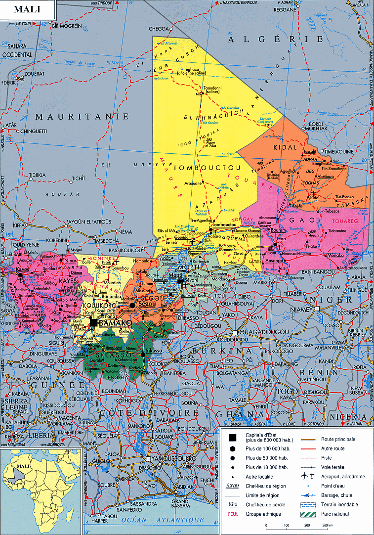
Mali
|
|
Click on map to see it in detail |
|
| Origin of the name Mali | Official name is Republic of Mali, which is derived from the name of the Mali Empire of the Fourteenth century. | |||
|
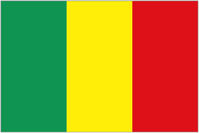
Symbols
|
Click on each link below to learn more about the symbols.
|
|||
|
Regions
|
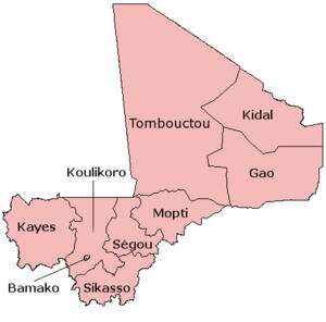
Sources: Wikipedia "Mali" |
|||
| Language | Mali’s official language is French, but numerous (40 or more) Africa languages also are widely used by the various ethnic groups. About 80% of Mali’s population can communicate in Bambara, which is the country’s principal lingua franca and marketplace language. | |||
|
History
|
History The area now constituting the nation of Mali was once part of three West African empires that controlled trans-Saharan trade in gold, salt, and other precious commodities. None had rigid geopolitical boundaries or ethnic identities. The Mali Empire arose from a small kingdom that expanded rapidly in the thirteenth century under the Malinké ruler Sundiata Keita. The empire reached the pinnacle of its power in the fourteenth century when it extended over a large area centered in the upper Niger and encompassed numerous vassal kingdoms and provinces. Under the Mali Empire, the ancient trading cities of Djenné and Tombouctou (often seen as Timbuktu) were centers of both trade and Islamic learning. Vassal provinces revolted in the late fourteenth century, and the Songhai Empire ultimately supplanted the Mali Empire in the fifteenth century. The empire eventually collapsed as a result of both internal and external pressures, including a Moroccan Berber invasion in 1591. The fall of the Songhai Empire marked the end of the region’s role as a trading crossroads. Following the establishment of sea routes by the European powers, the trans-Saharan trade routes lost their significance. In the late 1800s, Mali fell under the control of the French. By 1905, most of the area, then known as French Sudan, was under firm French control. French Sudan was administered as part of the Federation of French West Africa and supplied labor to France’s colonies on the coast of West Africa. In 1958 the renamed Sudanese Republic obtained complete internal autonomy and joined the French Community. In early 1959, the Sudanese Republic and Senegal formed the Federation of Mali, which gained full independence from France as part of the French Community on June 20, 1960. Following the withdrawal of Senegal from the federation in August 1960, the Sudanese Republic became the independent nation of Mali on September 22, 1960, with Modibo Keïta as president. Keïta quickly established a one-party state, withdrew from the French Community in 1962, adopted an independent African and socialist orientation with close ties to the Eastern bloc, and implemented extensive nationalization of economic resources. Following a progressive economic decline, however, Mali was forced to rejoin the Franc Zone in 1967. In November 1968, a group of junior army officers led by Lieutenant Moussa Traoré overthrew the Keïta regime in a bloodless coup and established a 14-member Military Committee for National Liberation with Traoré as president. The military-led regime attempted to reform the economy, but its efforts were frustrated by both political turmoil and a devastating drought in the Sahel lasting from 1968 to 1974. Under the provisions of a new constitution approved in 1974, the Second Republic of Mali became a single-party state under the Democratic Union of the Malian People (Union Démocratique du Peuple Malien—UDPM). After the fall of communism in the Soviet Union and Eastern Europe in March 1991, Malians engaged in forceful demonstrations against the Traoré regime that degenerated into widespread rioting. Military forces fired on the protesters, killing more than 100, following which the regime was overturned by a military coup led by Amadou Toumani Touré, a lieutenant colonel. The coup leaders soon formed a mostly civilian, 25-member Transitional Committee for the Salvation of the People, which then appointed a civilian-led transitional government. A national conference, including representatives of political groups, labor unions, student organizations, and other social groupings, was held in August 1991. It produced a draft constitution (approved in a national referendum in January 1992) that created a multiparty democracy, officially the Third Republic. The 2002 elections were a milestone, marking Mali’s first successful transition from one democratically elected president to another, despite the persistence of electoral irregularities and low voter turnout. Source: www.countrystudies.com, Library of Congress |
|||
| Government |
Government
Mali is a constitutional democracy, officially the Third Republic of Mali, inaugurated in 1992. A constitution approved by popular referendum in 1992 established Mali as a multiparty republic with a directly elected president. The president is elected to a five-year term and is limited to two terms in office. This official appoints the prime minister, who selects the other members of the council of ministers. The unicameral National Assembly consists of 147 deputies elected to five-year terms. "Mali (country)," Microsoft® Encarta® Online Encyclopedia 2008, Library of Congress - Country Profile: Mali |
|||
| Economy |
Economy Mali's key industry is agriculture. Cotton is the country's largest crop export and is exported west throughout Senegal and the Ivory Coast.[ During 2002, 620,000 tons of cotton were produced in Mali but declining cotton prices in 2003 reduced demand for the crop. In addition to cotton, Mali produces rice, millet, corn, vegetables, tobacco and tree crops. Gold, livestock and agriculture amount to eighty percent of Mali's exports. Eighty percent of Malian workers are employed in agriculture while fifteen percent work in the service sector. However, seasonal variations lead to regular temporary unemployment of agricultural workers. Mali remains heavily dependent on foreign aid.
The monetary unit is the CFA franc, consisting of 100 centimes (500 francs equal U.S.$1; 2008 average). The Central Bank of the West African States assumes Mali’s central banking functions.
Weights and Measures: Metric weights and measures are used.
Source: www.wikipedia.com |
|||
| Geography and Climate |
Mali is a landlocked country located in West Africa. At about 1.2 million square kilometers, it is almost twice the size of US state of Texas or about equal to that of Texas and California combined. It is bound by Algeria to the northeast, Mauritania to the northwest, Senegal to the west, Guinea to the southwest, Ivory Coast to the south, Burkina Faso to the southeast and Niger to the east. The country is flat except for the south, where the Futa Djallon Highlands and Manding Mountains rise to the border, and to the east, where the Bandiagara Plateau and Hombori Mountains also rise. The central area of the country consists of flood plains of the Niger Delta while northern Mali lies within the Sahara Desert and contains the vast plains of Tanezrouft and Taoudenni which are covered by shifting sand dunes called Ergs. The country is traversed by the Senegal and Niger Rivers with their tributaries. Source: www.atlapedia.com, www.countrystudies.com, Library of Congress Mali has three climatic zones. (1.) The Sudanic zone which receives 700 to 1,000 mm (28 to 39 inches) of annual precipitation. (2.) The Sahelian zone which receives 200 to 400 mm (8 to 16 inches) of precipitation and (3.) the Saharan zone which accounts for 40% of the land area and receives little or no rain. In general, there are also three seasons, (1.) a wet season from June to October, (2.) a cool dry season from November to February and (3.) a hot dry season from March to May. The northeasterly Alize wind blows cool air from November to January while in February the Harmattan, which is a dry dust laden wind from the Sahara Desert, prevails. Average temperature ranges in Bamako are from 16 to 32 degrees C (61 to 91 degrees F) in January to 24 to 39 degrees C (75 to 102 degrees F) in April. Source: www.atlapedia.com There are four sites in Mali listed on the World Heritage List:
|
|||
|
Population
Culture and Religion |
Population
Mali’s population encompasses a number of sub-Saharan ethnic groups, most of which have historical, cultural, linguistic, and religious commonalities. The Bambara are by far the largest single ethnic group, making up 36.5% of the population. Collectively, the Bambara, Soninké, and Malinké, all part of the broader Mandé group, constitute 50% of Mali's population. Other significant groups are the Peul (17%), Voltaic (12%), Songhai (6%), and Tuareg and Moor (10%). Mali historically has enjoyed reasonably good inter-ethnic relations; however, some hereditary servitude relationships exist, as do ethnic tensions between the Songhai and the Tuareg.
Source: www.wikipedia.com
Ethnic Groups, Culture and Religion
An estimated 90% of Malians are Muslim (mostly Sunni), 9% adhere to indigenous or traditional animist beliefs and 1% are Christian (about two-thirds Roman Catholic and one-third Protestant). Atheism and agnosticism are believed to be rare among Malians, most of whom practice their religion on a daily basis. Islam as practiced in Mali is moderate, tolerant, and adapted to local conditions; relations between Muslims and practitioners of minority religious faiths are generally amicable. The constitution establishes a secular state and provides for freedom of religion, and the government largely respects this right.
The Bambara, mostly farmers, occupy all of central Mali bounded by the Côte d'Ivoire frontier in the south and Nara and Nioro in the north. Malinke live chiefly in the regions of Bafoulabé, Kita, and Bamako. The Peul (or Fula), semi-sedentary herdsmen, are to be found throughout the republic, but mainly in the region of Mopti. The Songhai—farmers, fishermen, and merchants—live along the banks and islands of the Niger River, east of the inland delta. The nomadic Tuareg, of Berber origin, are mainly in the north, in the Adrar des Iforas. The Minianka, largely farmers, populate the region of Koutiala, and the Senufo, also farmers, are found principally in the region of Sikasso. The Dogon, often considered to be the first occupants of Mali, are believed to have survived owing to the inaccessibility of their villages in the Hombori cliffs. The Dogon have won international esteem for their unique ceremonial artifacts. The majority of the peoples in Mali are Negroid; the Tuareg are classified as Caucasoid; and the Puel (Fula) are of mixed origin. Source: www.wikipedia.com, The Encyclopedia of The Nations |
|||
| Fauna and Flora |
Fauna and Flora Mali’s vast expanses of bush and swamp used to provide a major sanctuary for West African wildlife, with the large predators – lions, leopards, cheetahs, hyenas – and many of the large prey mammals – from buffalo and warthog to hartebeest and reedbuck – present in significant numbers. Habitat destruction and massive over-hunting has seen the numbers seriously decline and the viability of surviving populations of many species in real jeopardy. Hippos are, however, still relatively common all along the course of the Niger, and Mali’s elephants also appear to be surviving and even increasing in numbers. The Saharan zone of Mali, an area of fixed dunes and false steppes, contains vegetation made up of thick-leaved and thorny plants (mimosas and gum trees). The vegetation of the Sahelian zone resembles that of the steppes, with thorny plants and shrubby savannas. The Sudanese zone is an area of herbaceous vegetation; its trees are bastard mahogany, kapok, baobab, and shea. Source: Rough Guides West Africa, June 2008, Encyclopedia of The Nations |
|||
| Environment |
Environment
The major environmental problem in Mali is the increasing desertification of the country. Soil erosion, deforestation, and loss of pastureland pose additional problems for the environment. Mali also has an inadequate water supply: only 74% of city dwellers and 61% of people living in rural areas have access to pure water. The country has 60 cu km of renewable water resources, of which 97% is used for farming and 1% is used for industrial purposes. Mali's cities produce about 0.4 million tons of solid waste. |
|||

|
We thank our West Africa Expedition Sponsors Please visit their websites
|

|
Contact us for information regarding sponsorship opportunities.
Join the Virtual Classroom. Complete the free registration form for your classroom today. Support the expeditions. Your donation will help to continue the research, documentation and Virtual Classroom web site presentation of these wonderful cultures and experiences to the broadest possible audience. To find out how you can help, please follow this link to our Helping Hand page. Thank you, now it's time to explore!
|