Welcome to the Oaxaca, Mexico
and the Day Of The Dead Celebrations
![]()
|
|
|
Oaxaca Journal (pronounced wa-HA-ka)
|
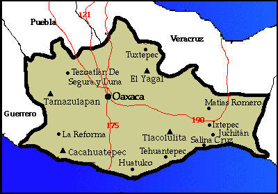
Click on either map to see it in detail State of Oaxaca
|
|
Overview
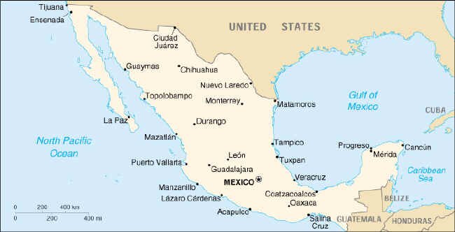
Mexico is a very large country spreading southeast from its northern border with the United States to the Caribbean Sea and from the Pacific Ocean on the west and south to the Gulf of Mexico on the east. Mexico covers almost 2 million square kilometers (460,000 sq. mi.) and also shares borders with Guatemala and Belize. Held within its boundaries is the Baja Peninsula, the longest peninsula in the world, the Sierra Madre Occidental mountain range with peaks rising to 3,700 meters (12,136 ft.), several active volcanoes, an isthmus just 220 km (136 miles) wide, fresh water springs, a rainforest, several deserts and some of the most beautiful beaches in the world. Eight mountain ranges divide Mexico into a system of plains known as altiplanos. In the west, the Sierra Madre Occidental range extends from the Sierra Madre range in the United States to south beyond Mexico City. In the east, the Sierra Madre Oriental runs southeast until it meets the Occidental near the capital. Between the two ranges lies the Central Plateau. Though it is arid much of the year, two rivers provide water for some of the country’s best farm and ranch land. It is also here that the bulk of Mexico's population resides. To the west, the coastal plain is hot and dry and to the east the plain is humid and wet with marshes and swamps fed by fresh water springs called cenotes. These coastal estuaries are the only ones in the world fed by underwater springs. Oaxaca The state of Oaxaca is the fifth-largest state in Mexico and is bordered by the states of Puebla and Veracruz on the north, Guerrero on the west, Chiapas on the east and by the Pacific Ocean on the south. The state reflects the whole of Mexico with a diverse landscape that extends from the mountains to the coast. The Sierra Madre del Sur mountain range rises from the west and stretches along the coast. Its Pacific-facing slopes have tropical forests flowing down to the hot and humid coast with its beautiful beaches. The inland Sierra Madre de Oaxaca mountain range has its origin in the center of the country, and its slopes include a cloud forest and stands of oak and pine. The two mountain ranges meet in the center of the state, forming the Valles Centrales and it is at this convergence that the city of Oaxaca is found. The warm and dry climate found at the joining of these three valleys has attracted people to this area for hundreds of years. The eastern part of the state lies on the Isthmus of Tehuantepec and the climate is hot and dry. What is the weather like in Oaxaca? Follow this link to The Weather Channel, or Weather Underground. Try converting the temperature in your town from Fahrenheit to Celsius. What time is it in Oaxaca, Mexico as compared to the time in your home town? Check this! |
|
|
|
|
The economy of the state of Oaxaca is largely dependent upon tourism. Visitors to the city of Oaxaca and the coastal communities of Huatulco, Puerto Escondido and Puerto Angel are the single most important source of income. In addition to working in the service sectors, many indigenous people make handicrafts to be sold to the tourists. Oaxaca has a rich indigenous culture and their handicrafts are beautiful and highly sought after.
Coffee is the second largest economic producer and accounts for 30% of the state’s exports. Government subsidies have helped farmers improve coffee yields and Mexico has become the world’s largest producer of organic coffee (grown with no pesticides or chemical fertilizers.) Mangos and pineapples also contribute to the economy and in addition, many farmers grow corn, beans, squash, bananas, oranges, and avocados either to sell or for their own use. Productivity however, is low because the quality of the soil has been degraded due to the decades-long incorrect use of pesticides. Forestry has also become a source of income for some communities and ejidos. Ejidos are small villages with communally owned land. The World Bank’s Community Forestry project provides technical assistance and management plans for indigenous communities and the programs have proven to be successful. Oaxaca is currently one of Mexico’s main timber producers. Overall, Oaxaca is a very poor state with its many natural resources underutilized. Programs to train indigenous people about the opportunities available are lacking, so many people are forced to migrate to the cities. This migration has caused the city of Oaxaca to double in size in the past 20 years. Migration out of the rural areas and into the cities has become a major source of rural income. Many indigenous people move "temporarily" from their traditional homes to the cities to work and they then send their income back to their communities. This method of increasing income has also brought many migrants from the Oaxaca area to the United States. Migrants come and may work for as long as 10 years to send enough money home to buy a house. Find out how much your money is worth in Mexican Pesos. Click here! |
|
|
|
|
|
The story of Mexico is old and long. Throughout the country, a variety of civilizations would rise to prominence at different times in different areas. Archaeologists have found evidence of human habitation as far back as 50,000 BC. Agriculture and communal living developed by 1500 BC. The high point of civilization in ancient Mexico was during the period between 200 BC and 900 AD, during what is referred to as the Classic Period. During the Classic Period, cities and religious centers were built throughout Central Mexico, the Yucatan and Guatemala. These cities were as grand as any city in ancient Europe. The area comprising the Mexican State of Oaxaca was the site of one of the first cities of the Classic Period. The ancient city of Monte Alban is close to the modern city of Oaxaca, about 350 miles south of Mexico City. It was built by the Zapotec people, who were among the first civilizations to develop a 365-day calendar and a primitive form of writing. The city had pyramids, temples, markets and large populations of people. However, by 900 AD, the city had been abandoned. There are many theories as to the reason or reasons that led to the city’s abandonment, but nothing is known for sure. Shortly after Monte Alban was deserted, the Mixtec people arrived. Although the city had been abandoned, the Zapotec people continued to live in the area. The new arrivals were welcomed and intermixed with the Zapotecs. This new culture is best known for their jewelry and the historical records they created. In the late 1400’s the more aggressive Aztecs arrived, however they were unable to completely dominate the area. One hundred years later, the first Spaniards arrived, eventually controlling the area just as they controlled the rest of Mexico. Oaxaca reflects the indigenous portion of Mexico. It is the Indian Mexico, with the largest population of indigenous people of any Mexican state. More people here speak indigenous languages than anywhere else. Although Spanish is the primary and official language, Zapotec is the dominant Indian language. During the 1920 revolution against Spain, Oaxaca remained loyal not to Mexico, but to Spain. Unlike other areas in Mexico under the Spaniards, the Indian villages had managed to retain their autonomy, (control over themselves) and therefore saw no reason to revolt against the Spaniards. Despite not joining in the revolution, two of Mexico’s greatest leaders came from Oaxaca, Benito Juarez and Porfirio Diaz. Today Oaxaca is one of Mexico’s poorest states. The area remains a land of small towns and villages. The economy is primarily agricultural and the land is held in common by the people with local leaders making the daily decisions.
|
|
|
|
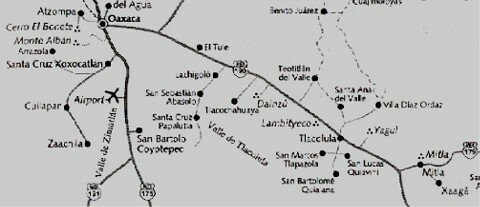
The Valley of Oaxaca has prehispanic ruins spread throughout its entire area. Being based in the city of Oaxaca, we have some of the largest and/or most excavated of the ruins close by. These are the ruins of Monte Alban, Mitla, Yagul, Lambityeco, Dainzu and Zaachila. Here are some of the highlights explorers can see.
Monte Alban Monte Alban sits on a high, 1200 feet above the valley floor. This location gave the residents a clear view of the Oaxaca valleys. The city was constructed by the Zapotecs who first moved to this site around 500 B.C. The city experienced its peak or golden age for a period of 500 years, ending around A.D. 600. During this time, the population of the city was nearly 25,000 people with an additional 100,000 people living in the valley below. After this golden age, and for reasons still unknown, the city was abandoned. It was during this time that Mitla grew in power and influence. During this period, the Mixtecs, who had migrated to this region, began to use the buildings at Monte Alban as tombs for their dead. All the treasure found in the tombs are Mixtec rather than Zapotec. (****SEE PICTURE OF INLAID SKULL****) At the center of the city is the Grand Plaza, one of the largest found in Mesoamerica and measuring roughly 900 ft by 600 ft (300 meters by 200 meters). On the south end of the plaza is the South Platform, on top of which stand two smaller pyramids. On the west side, archeologists discovered a wall with hundreds of relief panels that depict naked men in contorted postures. These are referred to as Danzantes, or dancers, although it is believed the panels represent sacrificed captives. In front of the South Platform is Building J. It is arrow shaped, and is the only building not built on a north south axis. It was likely used as an altar. On the north side of the plaza, a wide staircase leads to the North Platform. This is the largest structure at Monte Alban. Its features include the Sunken Patio (150 ft on each side) and three pyramids. Beyond the North Platform is a residential area where archeologists discovered more lavish tombs. At the present time the tombs are closed to visitors due to possible damage from a 1999 earthquake. Therefore we were unable to see the colorful frescoes and stucco masks of the Zapotec gods that adorn the walls of the tombs. Mitla Mitla reached its high point at approximately the same time that Monte Alban was abandoned. Although it was once believed that the Mixtec people dominated the resident Zapotecs, it is now held that the Zapotecs controlled and the Mixtecs only influenced society. Mitla is divided into 5 different groups of ruins. The most interesting of these are the Church Group and the Columns Group. The Church Group is so named because the Spanish built their Church of San Pablo in the middle of the group’s courtyard. This was a typical Spanish method by which they would symbolically dominate the Zapotec pagan religion. The most striking aspect of this group is the three partial panels of white on red Mixtec style murals. These murals are nearly 800 years old. (PICTURE) The Columns Group is the highlight of this ruin exploration. Although the Spaniards demolished several buildings and used the stones to build the Church, the remaining building shows the fabulous and incredibly intricate stone friezes, or mosaics that adorn the walls. Each small piece of stone was cut to fit the design then set in the wall like a piece of tile. There are 14 different geometrical designs spread out in the ruins, each thought to symbolize the sky, earth, the feathered serpent or other important cultural image. Upon entering the secondary courtyard of this group, there are two holes that lead to empty tombs, thought to have been plundered in ancient times. In one of the tombs is a large column. Local myth refers to this column as the Column of Life. Depending on with whom you speak, the myth claims that if a person hugs the column, the number of hand widths will tell you either how long you will live, or how many children you will have. Yagul These ruins are found on a mountain ridge from where the Zapotecs could view a large area of the valley and thereby protect their people from invaders. The buildings here are also lined with stone mosaics, like the ones found at Mitla. The major find here is the ball court. It is the largest ball court in Oaxaca and the second largest ever to be found in Mexico. The ball courts found in Oaxaca differ from those found elsewhere in Mesoamerica, as the Oaxaca ball courts were build without rings on the side walls. Lambityeco Lambityeco is a part of a large, unexcavated city called Yeguih. The exciting features of these ruins are the stucco masks found here. One of the masks represents the rain deity. The Zapotecs called this god Cocijo and the Mayas called him Chac. Two of the other masks are thought to be representations of the people buried in one of the tombs.
|
|
People and |
The state of Oaxaca has a very diverse population. Its 3.3 million people are made up of descendents from 15 different groups including the Zapotec, Mixtec, Chatino, Trique and Mixe peoples. They speak over 14 languages and 90 dialects. The terrain of the state of Oaxaca directly influences this cultural diversity as the mountain ranges and valleys separate the villages, and these isolated areas have developed their own languages, foods and customs. The Zapotecs are the largest ethnic group, numbering approximately 400,000. They have always lived in the Valles Centrales (central valleys) of Oaxaca and they built the hilltop city of Monte Alban. This city was the center of Zapotec culture and hit its peak between 300 and 700AD. After this time the city declined until it came under Mixtec influence around 1200 AD. They are currently mostly farmers but they also make handicrafts, mezcal and other products. The Mixtecs have the second largest ethnic population with approximately 300,000 descendents. They are potters and metalworkers and their culture thrived in harmony with the Zapotecs until they were both conquered by the Aztecs in the 15th century. The Mixe (pronounced MEE-hey) number around 90,000 and live in the northeast portion of the state. It is their music that binds them together as a people. "By exchanging music, the pueblos share their joys, their sadness, their emotions, their experiences". (Quote from Donato Vargas Pacheco in National Geographic, Nov. 1994). Community bonds are also important to the ethnic groups. For example, in the village of Santiago Yaitepec, the Chatino people believed so fiercely that alcohol was ruining their town that they occupied the mayor’s office for ten days to push for its banishment. Even though the bars and saloons were operated by the powerful in the town, the people prevailed and alcohol has been banned since 1982. The Trique people are a small group numbering only about 15,000. They live in western Oaxaca state and have a long history of violence and conflict over land rights. Each of the indigenous groups believes fiercely in being allowed to follow the traditions of its ancestors. Many of them still wear traditional clothing and prepare food following methods devised long ago. And while most people follow Catholicism, they also believe in including their original traditions. These intertwined beliefs combine to form very colorful and interesting villages and people.
|
|
|
|
|
The Day of The Dead Celebration
Every November 2nd is a joyous holiday, for this is the day the souls of the dead are believed to return to the earth. It is a significant festival that dates back to pre-Christian times. In the days preceding the holiday, families build altars in their homes called "offrendas". Traditionally the offrendas include an arch covered with marigolds and fruit, traditional foods as chicken mole and tamales and other favorite foods of the deceased. Candles and incense are also included. The shops and markets are filled with sugar candy skulls and skeletons portraying such everyday activities as dancing, playing the piano and bicycle riding. Beginning at midnight on November 1st (which corresponds with All Souls Day in other parts of the world) families visit graveyards with gifts and plates of the deceased’s favorite foods. Some villages celebrate with parades and dances and people dress in traditional costumes. At the island village of Isla Janitzio in the state of Michoacan, celebrations begin with a parade of decorated boats, the tradition of which dates back to a story of a pair of lovers who make their way to the island graveyard on that night. In pueblos all around Oaxaca state, moving, spiritual celebrations can be found. The municipal cemetery in the city is brightly lit with the illumination of thousands of candles and there are many offrendas dedicated to the memories of the deceased. In the main square called the Zocalo, artists build huge sand sculptures called tapetes. These usually depict skulls or skeletons also engaged in everyday rituals. Over several days, families get together to celebrate and visit. The cemeteries become gathering places for family and friends and it is a happy time for families who are reunited with their deceased.
|
|
|
Religion and belief in the supernatural are powerful influences in Mexico. They are reflected throughout the country, from the ancient pyramids and art to the cathedrals built by the Spanish.
To the ancient people in Mexico the world was a scary place full of evil. Their lives were at the mercy of their gods. The cycles of day and night, fall and spring and rain or drought frightened the people. Taking this into consideration, is it surprising that they practiced human sacrifice? They believed that human sacrifice was the greatest offering they could make to their gods. After all, was anything greater than sacrificing one of your own? The ceremony was not taken lightly. There was much ritual involved and the ceremonies were performed only at special times and in special places. The battles fought between the Indians and the Spaniards were more than just a war between people. They were battles between gods. When the Spaniards won, the priests were quick to seize on this significance in their attempts to convert the Indians to Christianity. However, it was easier to get the Indians to convert to the new religion than it was to have them give up their old ways. Although the Spaniards destroyed their temples, the Indians did not want to completely give up their gods. So in an effort to placate them and even as the Spaniards were building their churches on top of the sacred pyramids, the priests were adapting the traditional beliefs into the worship of local patron saints. They also encouraged the Indians to identify the Catholic saints with their own indigenous gods. As a result, Mexican Catholicism today embraces many different practices. |
|
|
|
| Flora and Fauna |
The terrain in the State of Oaxaca is extremely varied. The mountainous areas such as the Chimalapas forest, have pine and oak trees. In the cloud forests you can find orchids, mosses, ferns and vines. In the coastal areas there are tropical rain forests. The state of Oaxaca has a greater variety of trees than either of the countries of the U.S. or Canada.
The wildlife in Oaxaca state is as varied as its terrain and climate. In the more mountainous regions you can find deer, mountain lions (rare), raccoons, tlacuches (Mexican possum), hawks and eagles. In the more tropical areas you might see monkeys, boa constrictors, tapirs and iguanas. There are also peccaries (wild pigs) and armadillos. Along the Pacific Coast there are sea turtles, dolphins, whales and lots of sea birds. The Mexican people and their government have taken strides towards the protection their varied natural resources. Many parks, reserves and protected areas can now be found throughout the country. In the State of Oaxaca you can visit the cloud forests of the Sierra Norte, bird watch in the Parque Nacional Lagunas de Chacahua and the Laguna de Manialtepec, look for dolphins off the coast of Puerto Escondido and maybe see turtles on the beaches at Puerto Escondido and Mazunte.
|
|
|
|
| Turtles |
The state of Oaxaca is the home of nesting beaches for several of the world’s species of turtle. Most of the world's turtles are endangered. They have been hunted for their meat, eggs and shells for hundreds of years and until recently were on the brink of extinction. Worldwide conservation efforts are helping but turtles are still in danger.
Turtles usually lay their eggs on the beach where they were born, sometimes traveling many miles to return. They come ashore at night, dig a hole and deposit up to 200 eggs into it. The hole is then covered and the mother turtle returns to the sea. Six to ten weeks later the baby turtles hatch, digging their way out of the sand and beginning their dangerous journey to the ocean. Obstacles along the way include man, birds, animals and disorientation from man-made light sources. Just east of Puerto Escondido on the Pacific Coast lies one of the world’s main nesting grounds for the olive ridley turtle. The olive ridley is the only non-endangered turtle in the world and between May and January, approximately 700,000 turtles come ashore to lay their eggs. In order to assure the turtles’ survival, armed guards patrol the beach and no tourists are allowed. Two beaches in Oaxaca support nests for the rare leatherback turtle. The leatherback is the largest sea turtle and can grow up to 9 ft. long and live 80 years. It nests on Playa Mermejita and Barra de la Cruz in the most southern portion of the state. Despite international conservation efforts, turtles around the world continue to be killed for their shells, meat and eggs. Fishing boats also kill many by accidentally trapping them in their nets and drowning them. Killing sea turtles was officially banned in Mexico in 1990, however illegal hunting still takes place. Because of the on-going problem, the National Mexican Turtle Center in Mazunte was established in 1991. This community was chosen for the Center because it used to be a turtle slaughter ground. The government believed that if it could educate the local people about the turtles and provide them with an alternate source of income, they could begin to save the turtles. The Center has four specific goals: 1. to distribute information regarding conservation and legislation for turtle protection, 2. to conduct scientific and technological research for turtle management, development and conservation, 3. to promote the ecological tourism concept in the region and 4. to support community growth and development in the region. The Center has been a success and today educates visitors from around the world about efforts to protect the sea turtles.
|
|
|
|
|
Contact us for information regarding sponsorship opportunities.
Join the Virtual Classroom. Complete the free registration form for your classroom today. Support the expeditions. Your donation will help to continue the research, documentation and Virtual Classroom web site presentation of these wonderful cultures and experiences to the broadest possible audience. To find out how you can help, please follow this link to our Helping Hand page. Thank you, now it's time to explore! |
|
Home Welcome to Oaxaca Oaxaca Journal |
Kim and Don Greene, Authors; publication date October 1, 2000
Maps: Perry-Castañeda Library Map Collection © The General Libraries The University of Texas at Austin.