May 8
May 9
May 10
May 11
May 12
We passed over the Cassiar Mountain Range today also. During the Cassiar Gold Rush of 1872 a miner found a 72 oz. nugget (4.5 lbs or 2 kilos) of solid gold. This is the largest nugget ever found in B.C. Surprisingly, the Cassiar mountains also provide 75% of the world's supply of jade. They will be our companions for another day as we drive along the Alaskan (Alcan) Hwy. tomorrow.
So far we haven't seen any moose, despite all the highway signs warning us to watch for them, but today we did finally see a large group of caribou, standing in the middle of the highway, of all places. They moved off pretty quickly so we were unable to get a good photo of them. (Be sure to check out the online field guides at Arctic Wildlife Portfolio, Alaska Dept of Fish & Game). What we have seen quite a few of so far, are black bears. A couple of days ago we saw 9 bears and yesterday we saw 5. Today we also saw a beaver, a ruffed grouse and lots of squirrels.
Just before lunch today, the expedition vehicle's odometer turned over 100,000 miles of great exploring. We were so excited we had to take a photo of it! To celebrate we stopped for lunch on the shores of the Blue River, just south of the Yukon border. We thoroughly enjoyed watching the mini icebergs break off the accumulated shore ice and float down stream.
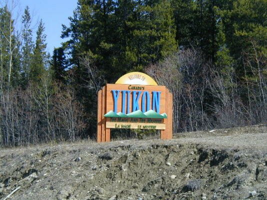
| Just short of the Alaska Highway we crossed the 60th Parallel and entered the Yukon. |
|
We then turned east on the Alcan to visit Watson Lake and the famed Signpost Forest. The first sign was placed by a homesick G.I. named Carl Lindley in 1942. As of today there are over 40,000 signs with all kinds of messages. A truly amazing experience to walk around and read the signs.

One of our challenges so far on this expedition has been to find good campsites at the end of the day. It is made a little easier by the fact that the sun doesn't set until late. We have over 16 hours of sunlight a day! It rises about 6AM and doesn't set until after 10PM. Incredible! Tonight's campsite was difficult to find, but it turned out to be quite spectacular. After finding a road off the Alcan (they are few and far between) we had to drive through mud and snow before we discovered an abandoned bridge over a river and parked the expedition vehicle at the end of it.
The perfect ending to the day came as we were looking upstream and watching what we thought was a log tumbling through the water. As it got closer we realized it was a river otter, playing in the water as he came downstream. We were able to watch him for a little while but as soon as he saw us, he dove under the ice and under the bridge and was gone downstream. What a wonderful ending to our day.
This morning the wind came up as we were sending our satellite update and we got so involved in just staying out of the wind that we packed up and hit the road as soon as we finished. It was only then that we realized that we'd forgotten to photograph and GPS this great site. I guess it will just have to stay a secret place!
We checked our maps and found that there was a double waterfall on the Rancheria River about 15 miles in the direction we were going, so we decided to get a nice hike in. The experience was actually quite hilarious.
The trailhead was identifiable only because there was a sign at it. Otherwise the trail was covered by up to 2 feet of snow. No problem. We felt that the snow was hard packed enough to us to walk on. No problem - for about a 1/4 mile. Then every step we made we sank further until we sank up to our knees and Don almost lost one of his boots.
|
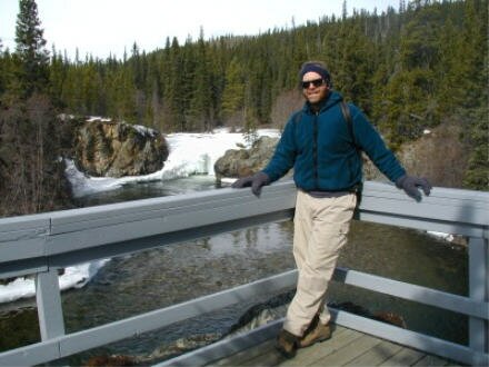
After we stopped laughing, we sought out a path with less snow and continued to the falls. When we arrived, we could only imagine what they must look like because they were covered by a thick sheet of ice. But on the wall directly across from the viewing platform, there was a beautiful cascade of icicles. |
|
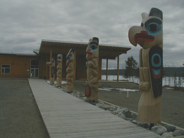
Our main stop today was the Tlingit (klink-it) Heritage Center. The one year old center was built to celebrate the culture of the Inland Tlingit people. The center is actually a place for the Tlingit to keep their traditions alive. For example, their dialect is a dying language as there are only about 12 people who can fluently speak and write the language so one of the speakers teaches classes at the center to those who want to learn the language. They also invite local carvers to spend the summer carving traditional masks and explaining their meaning.
When we arrived, we were the only guests so not only did we get a chance to have a private tour, we had the opportunity to discuss the culture in detail with the two Tlingit guides. The Inland Tlingit are made up of five family clans:
wolf - yanyèdí
frog - ishkitàn
beaver - rèshitan
crow - kukhittan
eagle - dakhlàwèdí
|
|
In front of the center are 5 totem poles, one for each clan. These totems are the only totems in the Yukon. |
The women are also trying to keep some of their traditions alive by continuing to make clothing out of animal skins. This entails a tremendous amount of work in that the animal skin has to be cleaned, washed, smoked (for color) and then cut and sewn into the garment. Oftentimes the garment is then decorated with bead work. It is a long but beautiful process.
The Tlingit have faced many obstacles in trying to retain their culture but one of their victories was receiving title to their homeland. It took twenty years but under the Land Act, they received title in 1992.
After leaving the Heritage Center we stopped at M'Clintock Bay where we heard that thousands of tundra and trumpeter swans along with thousands of other water birds stop during their annual migration north. We were not disappointed.
The ice on the bay melts earlier than on other lakes because of the warm water coming in from the M'Clintock River. The birds can stop and find food here while other lakes are still frozen. Using our Bushnell binoculars we could see countless birds in the the water. We then hiked to a spot only 50 feet away from the birds and were treated to a great show as the swans and ducks swam along the icy shore. It was funny to watch them feed on the underwater plants as they would stick their heads deep into the water and stick their little duck behinds high into the air. We learned also that the ducks stay close to the swans for protection because the swans are bigger and can see danger coming earlier and also when the swans bring food up from the bottom, (which they can reach with their long necks) the ducks can eat the leftovers.
Today we are spending the day in Whitehorse, the capital of Yukon. It is an attractive, lively city with an interesting history. It was named the capital in 1953 after the government moved it from Dawson City. Today nearly 2/3 of Yukon’s population lives in Whitehorse … and Yukon claims more moose than people!
The Klondike Gold Rush brought stampeders, (as the miners are referred to) the railroad and stern wheeled riverboats to Whitehorse in 1897. The river was the only highway until the Alaska Highway was built in 1942 and the stampeders generally had to stop in Whitehorse to dry out their belongings after running the White Horse rapids on the Yukon River just outside of town. The White Horse rapids were so named because the white water looked like the flowing manes of white horses.
In 1942 thousands of U.S. troops were stationed in Whitehorse while constructing the Alaska Highway.
After a couple of morning stops for supplies and groceries we headed over to the Visitor’s Center only to find it closed for lunch. This gave us an opportunity to treat ourselves to lunch in a restaurant. We tried a Quebec dish of french fries covered with gravy and cheese. It was quite tasty though not terribly healthy!
Back at the Visitor’s Center we viewed a video showing the gorgeous Yukon scenery (funny, their shots all had the sun shining) and found out that the Beringia Center was open (yeah!), but the S.S. Klondike was closed (boo!).
We drove by the S.S. Klondike and took some photos before stopping by a couple of schools to promote our expedition. We were warmly received at both Whitehorse Elementary and Josiah Smith Elementary schools.
|
After our school visits we checked out some of the other sights around town. At the airport we found what is supposed to be the world’s largest weather vane – an old DC-3 airplane. We can’t imagine how hard the wind would have to blow to spin it! |
|

We then continued on to visit the fish ladder built at the hydroelectric dam (which by the way, tamed White Horse rapids). The fish ladder wasn’t currently in operation because the fish haven’t started back upstream yet, but hopefully when we return in a couple of weeks we’ll be able to see it in use by the spawning salmon.
We then went hiking in Miles Canyon to see the Miles Canyon Bridge. The bridge crosses the river at the site of what used to be White Horse rapids. During the gold rush, horse drawn tramways were built on either side of the canyon to ferry the miner’s belongings around the rapids. The trams were built on a railway of logs acting as tracks. These people were really imaginative!
Next we traveled back in time about 10,000 years as we visited the Yukon Beringia Interpretive Center. The Center is dedicated to educating people about the Ice Age in Yukon and the great land bridge to Asia. They also have casts of skeletons of wooly mammoths, camels, sloths, bears and more. We were even given the chance to throw spears with an atlatl, a prehistoric weapon.
We found out that many of the fossils and remains of the Ice Age mammals are discovered by the placer gold miners as they dig through the permafrost. Also the Gwitch’in First Nations people have made great finds above the Artic Circle near the Crow and Porcupine Rivers – including the
12,000-24,000 year old traces of early man.
This was a very busy and interesting day in Whitehorse and we thoroughly enjoyed ourselves.
Today was overcast again with some snow flurries. It cleared up yesterday late afternoon so we were able to have our first really good campfire, but this morning it was cloudy again. Oh well. We’re really looking forward to having some sunny days to admire the fabulous scenery.
Hitting the road again we stopped a number of times to check out the local history. We stopped at Mendenhall Landing, which was a freight transfer point in the early 1900’s for goods shipped up the Yukon and Takhini Rivers. From the landing goods were loaded onto wagons headed for the Kluane mining operations.
Our next stop was the village of Champagne. This area has been inhabited for over 5,000 years and is currently by the Champagne-Aishihik First Nation people. In the early 1900’s the town was a stop on the Dalton Trail with a roadhouse and supply depot for the miners. Today most of the buildings are deserted and the upcoming realignment of the Alcan is sure to affect its history further.
The bridge at Canyon Creek was originally built by the Jacquot brothers around 1920 to allow miners and freight to cross what is now called the Aishihik River. It was rebuilt in 1942 by the engineers working on the Alcan and then again in 1987 by the Yukon Government.
|
We arrived at Kluane National Park Reserve in the early afternoon. This park, combined with the adjoining U.S. National Park Wrangell-St. Elias, was named a UNESCO World Heritage Site in 1980. These sites are set aside for the enjoyment of mankind for their uniqueness and beauty. In this case, the ice fields are the world’s largest non-polar alpine ice fields. The park also encompasses some of the world’s most beautiful glaciers. |
|

We had been hoping to take a “flightseeing” trip over the glaciers but the weather was so overcast that we decided to take a hike instead. We started from the day use parking lot at Kathleen Lake and proceeded to the trailhead for the 53 mile (85 km) long Cottonwood Trail.
After duly noting the bear warning sign, we proceeded on our way. Knowing that we wouldn’t be hiking the entire 53 miles, we chose a shorter loop. We had a beautiful walk through a wooded forest, noting all the different tracks we saw (Caribou, Elk and bird tracks) and animal scat (unidentifiable to us novices). We then looped around to the shoreline for the return trip. We walked along the edge of the frozen lake, noting when we would stop, the absolute silence and beauty. The mountains ringing the lake were shrouded in clouds, enveloping us in a world of white.
|
|
It was a challenge to walk this path as the snow was knee deep on the inland side of the path and the “we’re-not-so-sure-how-frozen” lake was on the other side. Periodically we could hear cracking sounds when we stepped so we made sure to stay right at the shoreline. |
As we got closer to the parking lot, the definitely-not-frozen part of the lake came up. We took turns throwing rocks into the water and listening to the tinkling cracking sound of the thin veneer of ice covering it.
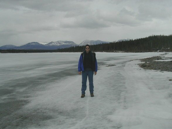
After leaving the lake we found a beautiful campsite along Quill Creek. We had to drive through snow two feet deep in places, but our trusty expedition vehicle got us to a dry spot where we were able to camp and enjoy an evening campfire.
This morning we did a short hike along Quill Creek admiring the Kluane and the Wrangle-St. Elias Mountains in the sunlight. These mountain ranges were also our companions on today’s drive. The mountains range in elevation from 8,000 feet in the Kluanes to 19,545 in the Wrangle-St. Elias’.
We crossed the highest point on the Alaska Highway between Fairbanks and Whitehorse at Bear Creek Summit, 3294 ft, and took a 360° photo at the top of the summit, from atop the expedition vehicle.
At lunch, we stopped at Sheep Mountain to see … Dall Sheep. Yes, they were right on the side of the mountain feeding high above us. Although they were just white specks in the viewfinder of the camera, the park service had a spotting scope available for great viewing.
We then took advantage of the clear day to set up our satellite system to update the website and receive your emails. We used our Jazz 500 inverter to power up both our computer and satellite terminal while we did our update.
Most of the rest of the day was spent dodging potholes and frost heaves on the highway. Spring and summer are maintenance time on the highway and there was plenty of maintenance happening. Many miles of roadway are being rebuilt so there was dust and mud galore. We also got caught in a rain/snow/sleet storm so at the end of the day, the expedition vehicle was so muddy we could hardly read our website address on the back. So we found a creek and washed off the mud by throwing buckets of water on it and scrubbing the back with a broom. Take a look at the fun.
Our campsite for the night was on the frozen edge of Small Lake and after a brief hailstorm, the sun came out and shone in the windows until we retired at 10pm. The sun isn’t setting until much later.