March 9, 2005
This morning dawned bright and hot as we headed out from Hopkins. Hoping to escape the heat (and the bugs), we headed into the foothills, up to the Cockscomb Jaguar Sanctuary. Designated in 1986, this sanctuary has the highest numbers of Jaguars in the country, but it is unlikely that we'll see one. They are nocturnal and very shy.
Stopping at what is now called Maya Center, we purchased our tickets for the Sanctuary from some of the Maya that were displaced when the Sanctuary was created. Habitation and hunting were no longer permitted but logging was. Go figure. These people are now trying to make a living through tourism and they have set up shops, tour companies, restaurants and hotels.
The Sanctuary has a wonderful campground, but they don't allow vehicles in it. However, the park ranger allowed us to park on the helipad, presuming that no helicopters would be landing, I guess. It turned out to be a great spot.
After lunch we headed out for a hike. It was still hotter than blazes and humid to boot. We enjoyed our hike however, seeing a number of birds that we had never seen before including a Rufous-tailed Jacamar, a Masked Tityra and a White-collared Manakin. When we got to Stann Creek, we met a couple tubing down the river. Now that looked like a great way to spend a hot afternoon. So we hiked back to the visitor center and rented a couple of tubes. Hiking upstream for about 20 minutes, we came to the tubing put-in. Very ungracefully, we hurled ourselves backwards into the tubes, and started floating. We knew the float would be over pretty quickly, so we tried various ways of slowing it down. We back-paddled for a while, we got out and walked back upstream, but our favorite way of extending the time was to find a shady, shallow spot in the slow moving creek and just stop for a while. The quiet broken only by the sound of birdsong was heavenly. We also saw more birds.
That evening it was still hot and pretty buggy, but our great spot on the helipad was a magnificent spot to see, yes, even more birds. We spotted a Crested Guan, a Montezuma Oropendola, a Golden-hooded Tanager, a Blue-grey Tanager, a Red-throated Ant Tanager, a Scarlet-rumped Tanager, a Chestnut-headed Oropendola, a nightjar and lots of doves.
This was our best birding day ever.
March 10, 2005
Last night, we had our first real rainstorm of the trip, with lots of lightning. It cleaned the truck up a little bit too.
In the morning it was still cloudy, so it was perfect for doing a hike. Along the way, we saw two Red Brocket deer. After breakfast, we drove out of the Sanctuary and headed back north. The rangers told us of a small plane wreck that could be found just off the road, so we stopped and hiked in for a look. The plane crashed while scouting jaguars about 10 years ago, fortunately no one was killed.
March 11, 2005
Since we had been unable to get extra pages for our passport last week, we decided to give it another try. Driving back to Belize City first thing in the morning, we were at the embassy ten minutes after they opened. There was no line, we filled out one piece of paper each, waited 15 minutes and voila, we had twenty new pages added to our passports. Now we have lots of room for the paperwork that is sure to come when we cross the upcoming borders with our vehicle.
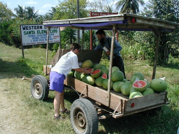
| Back on the road again, we headed west toward the dirt road that would take us to Belize's premier Mayan site, Caracol. Along the way we passed some Mennonite farmers selling watermelons, so we stopped and bought one as a treat. |
|
The road is 50 miles long with no services other than tourist lodges available. The advice in the guidebooks is: bring a 4X4, and enough food, water, gas and spare tires. This was really overkill, but the road is rough (although has been improved recently) and slow going. It was also quite beautiful with many ups and downs over mountains and water crossings.
Because we started on the road pretty late, we knew we wouldn't make it to Caracol today, so we decided to stop along the way and see Rio Frio Cave. This cave has an enormous arched entrance and is really more like a tunnel as you can walk through it and come out the other side. Stalactites and stalagmites cover the interior and the Rio Frio river meanders over boulders at the bottom of it.
Leaving the cave, we drove back through the little Forest Service town of Douglas Da Silva and stopped at their "camping ground". Alone as usual, we spent a lovely bug-less evening, watching birds (saw beautiful Swallow-tailed Kites), barbecuing and stargazing. We found our town also doubled as a barracks for British soldiers and for the Chinese workers on the new and controversial Chalillo Dam.
March 12
This morning we were up early to get on the road to Caracol. We still had about 25 miles to go and we didn't know what condition the road would be in. Our goal was to get to the ruins before any other visitors so we could have it to ourselves. All in all the road was about 20 miles of really bad road, 20 miles of OK road and the last 10 miles or so was actually paved!
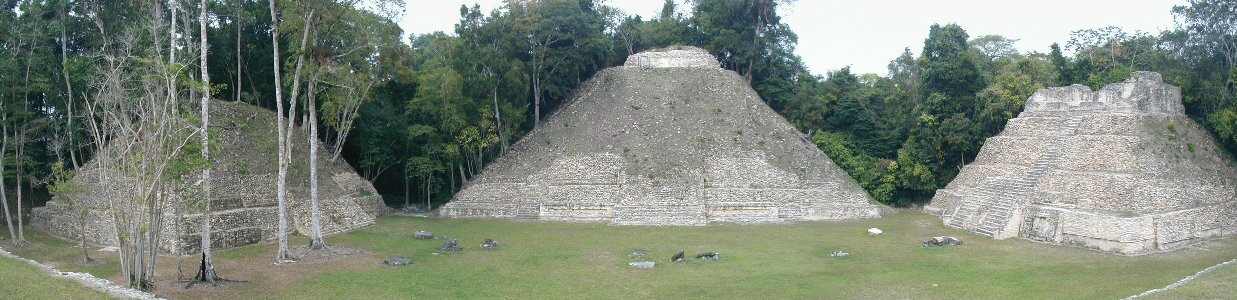
Our plan worked and we found that we would have Caracol to ourselves for about one hour. This was enough time to climb the Caana. To call this structure just a pyramid would not do it justice. Unlike the other Mayan ruins we have explored, the pyramids here are actually complexes where after we'd climb the main staircase, we'd find ourselves in an upper plaza with residences and additional temples that rise even higher.
The Caana complex rises some 43 meters (130ft) above the surrounding plaza and remains the tallest human-made structure in all of Belize. Once we climbed the staircase, we found three additional temples on the top. There are fiberglass casts in place of the original fabulous plaster masks and hieroglyphic panels that archaeologists found.
We spent an additional four hours exploring what is referred to as the "core structures". This area has three main Acropolis', two ballcourts and many other pyramid complexes which also included one for astronomical purposes. We couldn't explore the rest of the site as it is spread out over 100 square kilometers and contains an estimated 36,000 structures!
On the way back out along our 50 mile dirt road, we decided to stop off and check out the falls and pools at the Five Sisters Falls. After one particularly rough section of road, we heard what sounded like our extra fuel cans bouncing on the roof of our cab. This wasn't good. When we pulled off the road and Don climbed up on the roof, we found that the floor of our roof rack had sagged under the weight of the fuel and was bouncing on the roof of the cab. So after removing the cans to lighten the rack, we were able to slip two of our leveling blocks under the rack to spread out its weight. This seemed to work and as we drove on we had no more problems.
Five Sisters Falls is located about 2 ½ miles down an even worse road. The falls are actually more of a cascading area over rocks. We had a great view from the porch of the resort with the same name as we drank banana and vanilla milk shakes. The management of the resort even agreed to let us camp for the night, although not until we told them that the forest rangers had told us we could camp anywhere in the reserve.
March 13, 2005
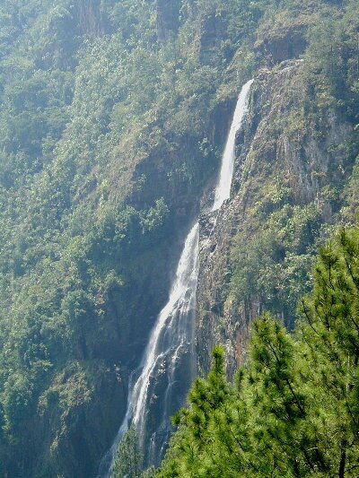
This morning we got a fairly early start, as we wanted to visit Thousand Foot Falls on our way to San Ignacio. According to our guidebook, the falls is actually 1,600 feet high and a “must see” in the area. The guidebook also indicated that the road to get there is only 4 miles long. After three miles, we came to an Inn that indicated the falls were still 5 miles away.
| Hmmm, that’s 8 miles, oh well, let’s keep going. After 6.4 more miles, we finally arrived at the falls. And they were nice, we’re just not sure it was worth 18.8 miles round trip (almost 11 miles further than we expected) down a really bad road. |
|
We continued out the road from Caracol, passing through small villages that had paved roads. It was quite funny to hit pavement for a mile or so in the middle of nowhere and then go back to dirt road. Eventually we reached the real end of the dirt road and headed to San Ignacio.
San Ignacio is on the banks of the Macal River and has two one-way bridges that lead into and out of the city. This is a diverse community where Belizeans of all creeds and colors happily reside. It is also the heart of backpackers Belize and every service imaginable can be found here. So, we took advantage of a laundry service and dropped our clothes off to be washed. We then headed out to Cosmos Camping and spent the evening relaxing on the beautiful grounds.
March 14, 2005
We spent this morning exploring downtown San Ignacio by bicycle. It is a compact little town and extremely lively. We were glad that we drove through yesterday (Sunday) when there was very little traffic, because today, the streets were full of cars, trucks, bicycles and pedestrians. We also discovered that shops close down from noon to 1:00pm for lunch (siesta). So at lunchtime we headed back to the campground and spent the afternoon doing some chores and maintenance. At about 4:00 we returned downtown to pick up our laundry and found that many shops close again from 4:00 to 5:00 for dinner (siesta). What a life!