Celebrate Semana Santa
The Guatemala Expedition
![]()
|
|
|
Come along to Antigua and the Highlands where our explorers will be joining Maya descendants in their colorful Easter celebration of Semana Santa (Holy Week).
(This expedition took place in April 2003) |
|
Semana Santa |
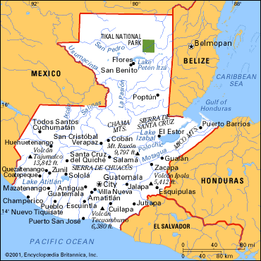
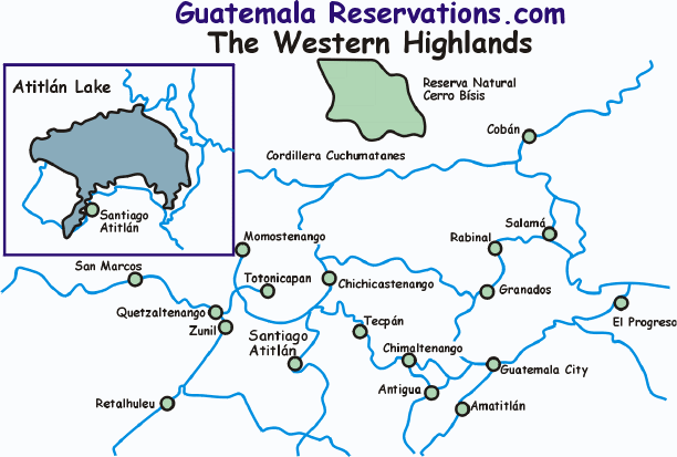
Click on either map to see it in detail
|
|
Geography The country of Guatemala is in Central America and is bordered by the Pacific Ocean on the south, El Salvador, Honduras and Belize to the east, and Mexico to the west and north. The total area of the country is 108,890 sq km with 460 sq km of that water. The size is slightly smaller than the U.S. state of Tennessee or the Eastern European country of Bulgaria. The terrain is mostly mountainous in the west and the east with rolling limestone plateaus in the north and narrow coastal plains along the oceans. The western mountains are a continuation of the Sierra Madre range that comes down from Mexico. Guatemala is a land of volcanoes with more than 30 of them and the tallest of these peaks is Volcan Tajumulco at 4,211 meters (13,812 ft.) Many of the volcanoes are active and let out constant streams of steam. The Pacific Coast is the agricultural area of Guatemala and crops of coffee, sugar, cacao and fruit are grown there. The lowland area of the Peten is a continuation of Mexico’s Yucatan jungle. Heat and humidity prevail in this area. Guatemala’s largest tract of virgin rain forest can also be found there. Guatemala sits at the confluence of three tectonic plates. This constant earthmoving has created the volcanoes and ancient collapsed volcanic cones have created the dramatic landscape of lakes such as Lago de Atitlán. Guatemala’s geologic history has also created a system of above-ground and underground caves. These caves have been used for millennia by the Maya for their ceremonies as they believe the caves link our world with the underworld. But beauty sometimes comes at a price. Devastating earthquakes have hit Guatemala many times during its history. The old capitol of Antigua had to be moved to Guatemala City because it was continually being destroyed. An earthquake in 1976 killed 22,000 people. Read about the Volcanoes of Guatemala here. Climate In Guatemala , altitude usually determines temperature. In the low lying areas of the Pacific coast and the Peten, average yearly daytime highs range between 28 degrees C (83 degrees F) and 32 degrees C, (90 degrees F) but can reach 40 degrees C (104 degrees F). In the highlands the daytime temperatures average between 20 and 25 degrees C (68 and 72 degrees F) all year long. At night though between December and February, temperatures can fall below 10 degrees C (50 degrees F). At the highest altitudes, frosts can happen any day of the year and snow can fall even in summer. Guatemala also has distinct wet and dry seasons. The wet season runs roughly from May – November and the dry season from December – April. What is the weather like in Guatemala today? Follow this link to The Weather Underground for the forecast for Antigua or the current temperatures. Or check out this satellite map from Weather.com. Try converting the temperature in your town from Fahrenheit to Celsius. What time is it in Guatemala as compared to the time in your home town? Check this! |
|
The observance of Semana Santa and Lent adds to the importance of Antigua (La Antigua) Guatemala. The city was declared a National Monument by the Guatemalan government in 1944, a Monument of the Americas by the General Assembly of the Pan American Institute of Geography and History in 1965 and named a UNESCO World Heritage Site in 1979 (site number 65). The early inhabitants of what is today called Guatemala were the people called the Maya. 4,000 years ago, the early Maya formed fishing and farming villages, lived in thatched huts and grew primitive crops. 2,000 years ago they had advanced to building simple temples and pyramids to their gods. By 600AD they had created an elaborate calendar and built magnificent temples. But merely 600 years later, population growth, food shortages, climate changes, trade declines and military conflicts had caused the swift decline of this Classic Mayan culture. In the early 1200’s a people called the Itzaes were still practicing Mayan beliefs along the shores of Lake Peten Itza near modern-day Flores but the coming of the Spaniards ended this final holdout of the ancient culture. In 1524, after concentrating on Mexico, conqueror Hernan Cortes sent his emissary Pedro de Alvarado to Guatemala. Determined to subjugate the Mayan population, Alvarado pillaged and murdered his way across the land. This allowed wealthy Europeans to come in and appropriate land from the indigenous population and enslave them to work it. Refusal to work meant certain death. During this time the Catholic Church stepped in and a Friar named Bartolome de Las Casas appealed to King Charles V of Spain to stop the violence. The King agreed and enacted the New Laws of 1542, which ended legal forced labor. With the killing stopped, the Catholic Church stepped in and started converting the Maya to Christianity. Three hundred years later, thoughts of independence from Spain finally came with the dissatisfaction of the Creoles (those born in Guatemala of Spanish parents) with the appointments of Spanish-born Guatemalans to high-ranking posts instead of native-born Guatemalans. Taking advantage of a Spain weakened after Napoleon’s invasion, the Creoles successfully revolted in 1821, and in 1823 joined with El Salvador, Nicaragua, Honduras and Costa Rica to form the United Provinces of Central America. This union only lasted until 1840 when the groups broke again into individual states. Liberal and Conservative groups vying for control over the next 120 years empowered dictator after dictator, always with the same results: the rich Ladino populations controlled the power and the money and the poor indigenous got poorer and more downtrodden. In 1952, plans for agrarian reform that would have given land to the poor, also negatively affected the U.S.-owned United Fruit Company and angered other large land owners. In response, the U.S. accused the democratically elected President Jacobo Arbenz Guzmán of being a communist and overthrew him in a CIA-organized military coup thus bringing in a series of U.S. supported military dictators. By the 1960’s the indigenous people decided to take things into their own hands and guerrilla groups began to form. Stresses on society had become intolerable and the poor indigenous began to rise up. By 1979 between 50,000 and 60,000 people had been killed and by 1982 four powerful guerrilla groups had joined together to form the URNG (Guatemalan National Revolutionary Unity). In the early 1980’s under the dictatorship of General Jose Efrain Rios Montt, the military suppression of the rebels in the countryside reached a peak. Since the government did not know the identities of the rebels leading the insurgency, a policy was formed known as “scorched earth” where they could exterminate entire villages to rid them of rebels. Over 400 villages were destroyed and their inhabitants massacred. Most of these atrocities were committed by the “Civil Defense Patrols”. These were villagers armed by the military, whose participation in the Patrols was compulsory for all men aged 18 to 60. It is estimated that an additional 15,000 people were murdered during Rios Montt’s 1-1/2 year reign. Rios Montt was deposed in a coup led by General Oscar Humberto Mejia Victores, but nothing changed for the people. The bloodbath finally led to the cutoff of U.S. Military assistance, which in turn led to the 1985 election of a civilian president who opened a dialogue with the URNG hoping to bring the decades-long civil war to an end. Talks collapsed however and the killing continued. In 1990, after 13 Maya (3 of them children) were killed in Santiago Atitlan, the people rose up and expelled the military and its Civil Defense Patrol from the town. This event helped to galvanize the people and finally in December of 1996, negotiations between the government and the URNG resulted in “A Firm and Lasting Peace Agreement”. |
|
Guatemala ’s biggest business is the export of coffee. Coffee is grown mainly on the Pacific slope and in the department of Alta Verapaz. Other export crops include sugar, cotton, flowers, natural rubber and bananas with 50% of the population working in agriculture. The Motagua Valley also supports banana and sugarcane plantations and the rolling hills of Alta Verapaz also support dairy farming. Tourism is the second largest industry with 35% of the population employed in services. The remaining 15% are employed by industry with Guatemala City being the industrial and commercial center of the country. The El Peten department in the north depends mostly upon tourism and as it is in this area that the great ruins of Tikal are located. Guatemala suffers from the regional legacy of the "banana republic": the inequitable distribution of land and wealth, uneven development, and the dependence on a few export crops for its economy mainstay. The poor distribution of land is the single most important factor to explain the poverty and quality of life in Guatemala. Nearly 90 percent of the farms are too small to provide adequate subsistence, while 2 percent of the farms use up 65 percent of the land. Find out how much your money is worth in Guatemala Quetzals. Click here! |
|
Ethnic Groups |
The People
The Maya civilization lasted 3,000 years. During that time they created a calendar, a written language, art and architecture. Today's Maya still play an important role in today's society. They practice a religion that is a mixture of their ancient beliefs and Catholicism, they live off the land much as their ancestors did and they create beautiful pottery, baskets and textiles that are valued the world over. The inhabitants of modern-day Guatemala can generally be broken up into two main groups. Fifty-five percent of the people are referred to as Mestizos or Ladinos. These people are of mixed Mayan and European ancestry. The vast majority of Ladinos live in the cities. Forty-three percent of the people are indigenous Maya and they live mainly in the rural areas. The remaining two percent are White/Black/Asian. The total population of Guatemala as of July 2002 was estimated to be 13,314,079. About 40% of all Guatemalans live in cities with nearly a quarter of them in Guatemala City alone. At the other extreme, less than 5% of Guatemalans live in the department of El Peten in the north. Language Groups Language groups generally identify the Maya people of Guatemala . The official language of Guatemala is Spanish but there are 23 Mayan languages plus Garifuna also recognized by the government. 60% of the population speaks Spanish while 40% speak an indigenous language. The most widely spoken Maya language in Guatemala is K’iche’ which has nearly a million speakers. 686,000 people speak Mam, Q’eqchi’ has 361,000 speakers while Q’anjob’al is spoken by 112,000 people. Other languages spoken include Achí, Akateko, Awakateko, Chalchiteco, Ch’orti, Chuj, Itzá, Ixil, Poptí, Kaqchikel, Mopan, Poqomam, Poqomchí, Sacapulteko, Sipakapense, Tektiteko, Tz’ultujil, Uspanteko and Xinca. For an example of a Mayan Folktale, read the Mayan Creation story. |
|
The dominant religion in Guatemala is Catholicism, however there are small percentages of Protestant, Jewish and Muslim. A key way in which the Maya resisted the Spanish was by preserving their own rites and customs within Catholic ritual. This process of "syncretism" has always been present and challenged the church. It wasn't until the Maya themselves became clergy that the process was truly accepted. As a result, Guatemala's Catholicism today embraces many different practices. One view of "syncretism" can be found in the village of Santiago Atitlán. The church there is one of the oldest on the continent. More than 50 large wooden statues of saints line the interior walls, all of which are wrapped in colorful indigenous scarves and dressed in the traje (traditional clothing) typical of Santiago. Some saints weep, hands outstretched, others bleed from painted wounds, while Mayan women kneel at the altar praying. Next to the church is the small chapel of Maximón, a local maize (corn) god who loves to drink and smoke. Every Easter week Maximón holds court in his special chapel while hundreds of visitors ask him to grant a wish, plying him with cigars and rum. Read the story Renewal of Life in Santiago Atitlán. Other forms of values are the customs held by the indigenous Maya living in the highlands. Read about the woman's traditional dress, the traje, which is a combination of a skillfully woven, multicolored blouse called a huipil, or a corte, a woven wraparound skirt that reaches to the ankles, and is held together by a faja (sash) at the waist. |
|
Much has been written about the Mayan archaeological sites in Guatemala and Central America. Since this Expedition is focused on the Maya celebration of Easter featuring their form of Christianity, we recommend you search for archaeological information on other websites. You can start with a reading of Heart of The Mayan World. We then recommend a search on Google. |
| Flora and Fauna |
Flora More than 8,000 species of plants can be found in Guatemala and are found in several vegetation zones. Several species of mangroves grow along the coastal plains. Mangroves consist of salt-water loving trees that grow tightly intertwined at the water’s edge and provide a haven for fish and crustaceans below the water and many species of birds above. In many areas of Guatemala the mangroves are at risk because shrimp farmers pull them out to create shrimp farms. Guatemala also has a tropical moist forest. This is similar to a rainforest with the same types of trees, but instead of it having rainfall all year long, there is a dry season from December to April. Some of the plants that grow in the moist forest include allspice, a spice that smells like a combination of nutmeg, cinnamon and clove, chicle, which is the basis for chewing gum and comes from the sapodilla tree and the breadnut tree which produces a grape-sized fruit that is used in breads, tortillas, soups and drinks. There are also mahogany, cedar, mayflower and palm trees growing in the moist forest. These trees are all at risk from illegal loggers, cattle ranchers and farmers. Even sustainable plants like the xate palm (used around the world in flower arrangements) are at risk because of over cutting. Guatemala also supports a desert microclimate in the Motagua valley where cactus and scrub known as monte bajo grow. In the highlands of Alta Verapaz the trees grow in a cloud forest. Due to the continual dripping from the moisture, this forest of oaks, laurels, gums and ferns also supports epiphytes such as orchids and mosses. Guatemala’s national flower, the rare white nun orchid can be found here. Guatemala also supports a pine/oak forest at higher altitudes and has a pine tree called pinabete that is endemic to Guatemala and parts of Mexico and Honduras. A popular tree at Christmas time, it is now vulnerable to extinction. The national tree of Guatemala is the ceiba. It can be found in many communities shading the main plaza. Its branches shelter many species of orchid, fern, cacti and bromeliad. Iguanas and other reptiles can be found in its higher branches. Fauna Guatemala has 19 ecosystems with 250 species of mammals, 600 species of birds, 200 species of reptiles and amphibians and many species of insects. Mammals Some of the grazing mammals that inhabit the lowlands are the Baird’s tapir, the white-tailed deer, the brocket deer and collared and white-lipped peccaries. There are also two primate species that are native to Guatemala, the howler monkey and the black-handed spider monkey. Guatemala has over 100 species of bats, the most common of which are leaf-nosed bats and funnel-eared bats. Rodents comprise more than half the mammal population of Guatemala and along with mice, rats and squirrels, include anteaters, sloths and armadillos. There are also a number of felines like the jaguar, puma, margay and ocelot and canines like the coyote and gray fox. There are also raccoons and coatimundi. Marine mammals include the Caribbean manatee, porpoises and dolphins. Reptiles and Amphibians Central America’s most renowned venomous snake is the fer-de-lance. There are also the Central American rattlesnake and the coral snake. Non-venomous snakes include the boa constrictor. Other reptiles include the Morelet’s crocodile, the green iguana, the basilisk lizard and a number of species of frogs. Marine reptiles include the poisonous sea snake and the crocodile and sea turtle species include the Atlantic green turtle, the East Pacific green turtle, the olive ridley, the green ridley, the leatherback, the loggerhead and the hawksbill. Birds Guatemala ’s bird population is abundant and diverse with over 700 species. Some of the species include the increasingly rare resplendent quetzal (the national emblem), the Atitlan flightless grebe, the ocellated (Peten) turkey, the harpy eagle, the scarlet macaw, the blue crowned mot-mot and the keel-billed toucan. The people and their government have taken strides towards the protection of their varied natural resources. Many parks, reserves and protected areas can now be found throughout the country. Read all about the Maya Biosphere. The Maya Biosphere Reserve is an ecosystem of more than 6,000 square miles in Northern Guatemala, Belize and Mexico. Although poverty has often been a focus of deforestation when the landless poor occupy land, the expansion of cattle ranching has greatly accelerated deforestation. Guatemala also has several locations that have been named UNESCO World Heritage Sites. |
|
Contact us for information regarding sponsorship opportunities.
Join the Virtual Classroom. Complete the free registration form for your classroom today. Support the expeditions. Your donation will help to continue the research, documentation and Virtual Classroom web site presentation of these wonderful cultures and experiences to the broadest possible audience. To find out how you can help, please follow this link to our Helping Hand page. Thank you, now it's time to explore! |
Source: Lonely Planet Publications, Guatemala In Focus, CIA World Fact Book 2002, The Constitution of the Republic of Guatemala, Moon Handbooks, Guatemala Adventures in Nature
Kim and Don Greene, Authors; publication date April 10, 2003