Valley of The Gods
10/10
Our next destination was the San Juan River area in southeastern Utah. However, along the way we were planning to make some stops to find Ancient Puebloan ruins, check out Lake Powell and explore the mini Monument Valley of The Valley of the Gods.
Our way south took us the better part of a day and a half. The storm that dropped snow in the mountains created some high wind that tried to blow us off the back roads. After fighting the wind for several hours, we decided to call it an early day and stopped in the small town of Hanksville so that we could catch up on your emails and update the web site. Working on our laptop put our Store4Power Portawattz 140 power inverter to the test. The inverter flawlessly converted our 12 volt power produced by our EV Solar Products solar panels to 110 volts so that we were able to power our computer.
On the second day we stopped for lunch on Lake Powell, near the bridge that spans the Colorado River at the northern edge of the lake. The water level in the lake was down over 30 feet from its maximum. We could really see the results of the drought that has been affecting this area for the past few years.
Driving through Utah and its magnificent canyons, I couldn’t help but imagine all of the beautiful canyons and ruins that were covered up by the waters of Lake Powell.
We continued on. Our path took us along White Canyon. As you can image, the canyon at the bottom of the valley was … white! Once again, the beauty of the area constantly amazed us. We could see slot canyons that appeared like knife slices and every now and again we glimpsed rock overhangs that must surely house old Indian ruins.
As we neared Fry Canyon, we saw that our map indicated that there were ruins in the canyon, but the location was pretty much indistinct. We pulled off the highway, put our expedition truck in four-wheel drive, and headed down a trail towards the canyon.
| After a little 4 wheeling and some scrambling over rocks, we actually found the ruin! Set into a small alcove, the ruins were roofless, but otherwise looked very intact. We set up camp and watched as the setting sun slowly illuminated the ruin walls. The view from our ledge was fantastic. |
|
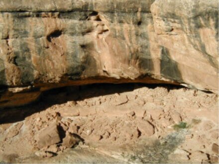
In the morning we set out to find a way to reach the ruins and do some exploring. We soon found the reason why the Indians built where they did. They were in a very defensible position and the only way down we could find required more rock climbing experience than we have. Not only that, but we found we would have to traverse another slot canyon, then do more rock climbing up the other side to reach the ruins. From the graffiti on the rocks below the ruins it was obvious that others before us had reached the ruin, but it was too much for us.
| We continued on our way to The Valley of the Gods. The Valley is similar to Monument Valley, minus the view from the rim. The road through is a rough dirt road but it was a great chance to see the "monuments" up close. The monuments are actually buttes that have remained standing long after the cliffs they were attached to eroded away. |
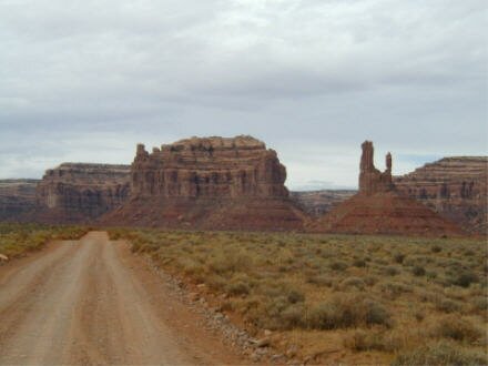
The monuments have whimsical names like "woman in a bathtub, the rooster, the hen and General Degaulle’s troops (?). We even discovered the remains of a rock road built by Mormon pioneers in the 1800’s on their way across this wilderness.
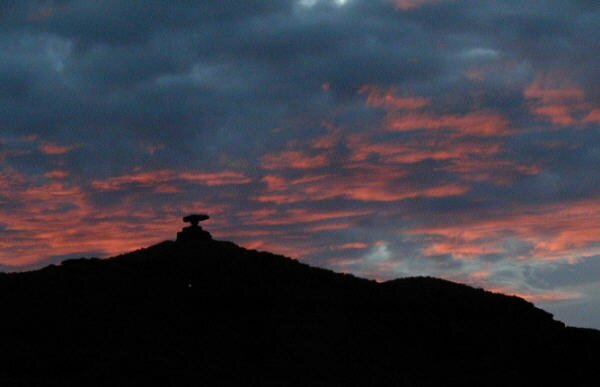
From The Valley of the Gods, it is just a short drive to the site of our intended camp in site of Mexican Hat rock (it looks like a Mexican sombrero) along the San Juan River. This will be the location where we intend to inflate our Aire inflatable kayak and negotiate some river rapids!
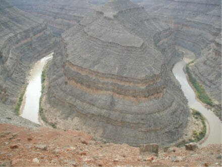
On the way, we took a little detour to look down at the Goosenecks of the San Juan River. This area is past where we intend to kayak so we wanted to get a good look at probably the best example of an entrenched gooseneck in the United States. Goosenecks are where a river meanders in tight curves.
|
From an overlook we could see that the river had cut its way down through 1100 feet of rock! Here the river follows a series of truly massive curves over a course of six miles. The amazing part is that these six miles of meandering covers a distance of only a little more than one mile when measured in a straight line. (see panoramas)
|
|
|
We set up camp below Mexican Hat on the banks of the San Juan River. |
In the morning we were excited to be getting on the river, but as we ate breakfast the wind started to build in intensity. When the wind started blowing the sand into our teeth, we regretfully decided that we would have to break camp and cancel our adventure on the river.