![]()
THE GAMBIA
Expedition Journal
Photographs
Origins
Symbols
Regions
Languages
History
Government
Economy
Geography and Climate
Population, Ethnic Groups, Culture and Religion
Fauna and Flora
Environment
Resource Links
Lesson Plans
Check out the Route Maps
Send us an Email
Camping Information
|
Expedition |
|
Lend a Helping Hand You can help make the Virtual Classroom available to students by making a donation today. |
| World of Wonders Project: The West Africa Expedition |
|
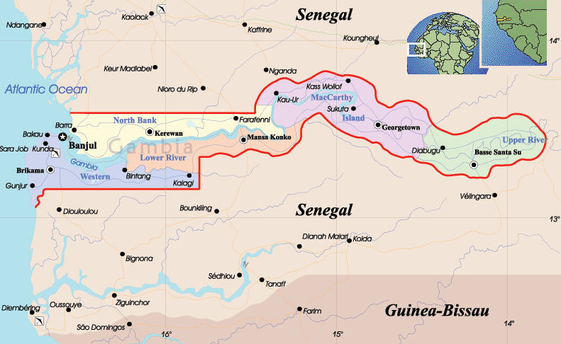
The Gambia
|
|
Click on map to see it in detail |
|
| Origin of the name The Gambia | Official name is the Republic of The Gambia, yet more commonly known as Gambia. It is named for the river that flows through it. | ||
|
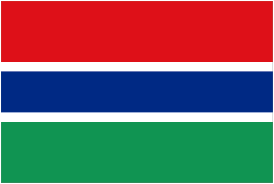
Symbols
|
Click on each link below to learn more about the symbols.
|
||
|
Regions
|
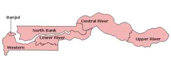
|
||
| Language | Official language is English. | ||
|
History
|
History Present-day Gambia first belonged to the Empire of Ghana and then in the 10th century to the Songhai. In the 13th century it was incorporated into Mali. Portugal established a colony at the river Gambia in 1455. It was claimed by England in 1588, but no settlement was founded. In 1651 Courland founded a colony. This lasts until 1661 (with a short Dutch interruption in 1659/1660), when it was occupied by England. Courland cedes the colony de jure in 1664. Courland seizes the colony in 1651, but in 1664 an English colony is founded. In the eighteenth century France and Britain dispute the area and it is occupied by both powers consequently.
After a brief flirtation with dictatorship, the 30-year-old Jammeh bowed to international pressure, inaugurated a Second Republic and won the 1996 presidential election comfortably. Human-rights groups and democratic watchdogs were all put at high alert when, in 2004, prominent journalist Deyda Heydara was assassinated after having expressed his opposition to a new controversial media law, and in March 2006, an alleged coup d’état attempt led to the ‘cleansing’ of governmental ranks. That same year, the country again prepared for elections, this time against a background of increasing autocracy. It now seems unlikely that the future direction of The Gambia will change dramatically, as Yahya Jammeh was sworn in as president for another five years after defeating his main rival Oussainou Daboe.
electionworld.org, lonelyplanet.com |
||
| Government |
Government
Before the coup d'état in July 1994, The Gambia was one of the oldest existing multi-party democracies in Africa. It had conducted freely contested elections every 5 years since independence. After the military coup, politicians from deposed President Jawara's People's Progressive Party (PPP) and other senior government officials were banned from participating in politics until July 2001. wikipedia |
||
| Economy |
Economy
Despite the growth in importance of tourism, the economy of The Gambia is still predominantly agricultural, with the vast majority of Gambians earning their living from the land and sea. Groundnuts are the traditional cash crop. The Gambia also exports produce to Europe.
About three quarters of the population is employed in agriculture. Rice, millet, sorghum, corn, and cassava are grown for subsistence, and cattle, sheep, and goats are raised. There is also a fishing industry. The main industrial activities center around the processing of agricultural products and some light manufacturing. Tourism, which suffered following the 1994 military takeover, rebounded in the late 1990s. Besides peanut products, dried and smoked fish, cotton lint, palm kernels, and hides and skins are exported; foodstuffs, manufactures, fuel, machinery, and transportation equipment are imported. India, Great Britain, China, and Senegal are the country's leading trading partners. The Gambia is one of the world's poorest nations and relies heavily on foreign aid.
Weights and Measures: Metric weights and measures are used.
Monetary Unit: The Dalasi is a paper currency of 100 Bututs. There are coins of 1, 5, 10, 25 and 50 Bututs and 1/2, 1, and 5 dirhams, Notes are in denominations of D100, 50, 25, 10 and 5. B1 = $0.037 (or $1 = D26) as of 2009.
infoplease.com |
||
| Geography and Climate |
Geography
The Gambia is the smallest country on mainland Africa, bordered to the north, east, and south by Senegal, and has a small coast on the Atlantic Ocean in the west. Its borders roughly correspond to the path of the Gambia River, the nation's namesake, which flows through the country's center and empties into the Atlantic Ocean. The country is less than 48km wide at its greatest width. The country's present boundaries were defined in 1889 after an agreement between the United Kingdom and France.
The Gambia has a subtropical climate with distinct cool and hot seasons. From November to mid-May there is uninterrupted dry weather, with temperatures as low as 16°C (61°F) in Banjul and surrounding areas. Hot, humid weather predominates the rest of the year, with a rainy season from June to October; during this period, temperatures may rise as high as 43°C (109°F) but are usually lower near the sea. Mean temperatures range from 23°C (73°F) in January to 27°C (81°F) in June along the coast, and from 24° C (75°F) in January to 32°C (90°F) in May inland. The average annual rainfall ranges from 92 cm (36 in) in the interior to 145 cm (57 in) along the coast.
There are two areas in The Gambia on the World Heritage List:
Sources: www.infoplease.com******* , unesco |
||
|
Population
Culture and Religion |
Population, Ethnic Groups, Culture and Religion
A wide variety of ethnic groups live in The Gambia, each preserving its own language and traditions with minimal intertribal friction. The Mandinka are the largest ethnic group with 40% of the population, followed by the Fula, the Wolof, the Jola, and the Serahuli. The Aku also live here although only constituting a small community. Approximately 25,000 non-Africans live in The Gambia, including about 20,000 Europeans and 2,500 people of Moroccan origin. wikipedia |
||
| Fauna and Flora |
Fauna and Flora Gambia's landscape is completely flat. Vegetation changes as you move along the meanders of Gambia River. Near the estuary, the mangrove occupies the river banks. As you go up river, you will find forest-galleries and savannah. Gambia hosts more than 560 bird species. This concentration is due to the country's geographical position. Migratory birds make a stop there, particularly waterbirds that come in crowds from Europe during winter. The reserves and national parks host all kinds of wild animals, including many monkey and chimpanzee species. |
||
| Environment |
Environment
The Gambia's environmental concerns include deforestation, desertification, and water pollution. Deforestation is the most serious problem, with slash-and-burn agriculture the principal cause. In the 1950s, 34,000 hectares (84,000 acres) were set aside as forest parks, but by 1972, 11% of these reserves had been totally cleared. As of 2001, only 2% of the total land area is protected. During 1981–85, deforestation averaged 2,000 hectares (5,000 acres) per year. Only 9% of the forests in The Gambia have survived the expansion of agricultural land and the use of trees for fuel. A 30% decrease in rainfall over the last 30 years has increased the rate of desertification for The Gambia's agricultural lands. Water pollution is a significant problem due to lack of adequate sanitation facilities. Impure water is responsible for life-threatening diseases that contribute to high infant mortality rates. According to the World Resources Institute, 3.2 percent of Gambia's land area is under some form of protection. The country is home to 974 species of plants, 117 mammals, and 535 birds. Source: Encyclopedia of Nations |
||

|
We thank our West Africa Expedition Sponsors Please visit their websites
|

|
Contact us for information regarding sponsorship opportunities.
Join the Virtual Classroom. Complete the free registration form for your classroom today. Support the expeditions. Your donation will help to continue the research, documentation and Virtual Classroom web site presentation of these wonderful cultures and experiences to the broadest possible audience. To find out how you can help, please follow this link to our Helping Hand page. Thank you, now it's time to explore!
|