Come Explore Baja California
Mexico's Outback
![]()
|
|
|
Explore the natural environment and travel the ancient routes of the native people and the early explorers through the wilderness of Baja California. Driving in our specially equipped, satellite linked expedition vehicle the expedition began on January 31, 2002. Follow the migration of the California Gray Whale to the calving lagoons in Baja Sur. Explore the abandoned missions left behind by the early Spanish missionaries and trek to the rock art that the ancient native people left behind. Explore the National Parks and the UNESCO World Heritage sites that preserve the beauty of the region. |
|
Baja Journal (pronounced BA-ha) Photographs |
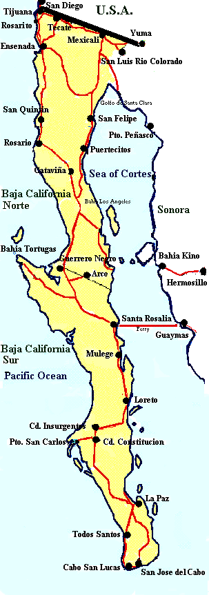 Click on the map to see it in detail
|
|
Mexico is a very large country spreading southeast from its northern border with the United States to the Caribbean Sea and from the Pacific Ocean on the west and south to the Gulf of Mexico on the east. Mexico covers almost 2 million square kilometers (460,000 sq. mi.) and also shares borders with Guatemala and Belize. In the northwest portion of the country is the Baja Peninsula. At 800 miles long it is one of the longest peninsulas in the world. The peninsula is also very narrow averaging less than 70 miles in width with the narrowest part being 26 miles wide. 20 million years ago, there was no Baja Peninsula. The land was originally connected to the Mexican mainland with the tip of Baja located near Puerto Vallarta. Thanks to the San Andreas Fault and the movement of the earth’s plates Baja is now is nearly 300 miles away from its old neighbor. Baja's mountains form a largely unbroken barrier running the entire length. The mountains are actually a series of ranges each with their own name. The mountains average between 2,000 and 3,000 feet. The tallest mountains on the peninsula are the twin peaks of Picacho del Diablo, or Devil's Peak, which rise to 10,154 feet. There are four main desert areas on the peninsula. These are the San Felipe Desert, the Central Coast Desert, the Vizcaíno Desert and the Magdalena Plain Desert. Being a peninsula, two of Baja three sides are water. The Pacific coast is characterized by ocean swells and the occasionally heavy surf. Due to upwelling of deep ocean water, the water temperature is cool though it warms as the water mover south. The Sea of Cortez is over 600 miles long and in places, the depth reaches more than 14,000 feet. With its location along the San Andreas Fault, the Cortez is very seismically active. Earthquakes in the 1800's destroyed the towns of San Ignacio and Loreto. Due to its long narrow shape, the Cortez produces one of the largest tidal ranges in the world. Near the Colorado River Delta the tides can fluctuate up to 31 feet between high and low tides. Water temperature can also vary by large extremes. Depending on the season and the location, the temperature can vary from a high of 91°F to a low of 47°F. Climate Much of northern Baja California has a climate similar to Southern California. Along the Pacific coast the summers are warm with cool night, while the winter is cool with chilly nights. The Sea of Cortez has hot summers days and humid nights, while the winter is cooler with strong cold winds. Most of the rain falls along the Pacific coast in the winter, with an average of 10 inches of rainfall a year. The southern half of Baja is more sub-tropical. Summers are hot and humid, while winter evenings can be cool. Rain is rare and mostly in the summer in the form of violent storms. What is the weather like in Baja California today? Follow these links to The Weather Underground for La Paz, Loreto, Cabo San Lucas or Tijuana. Or check out this satellite map from Weather.com or from Earthwatch.com. Try converting the temperature in your town from Fahrenheit to Celsius. What time is it in Baja California as compared to the time in your home town? Check this! |
|
|
|
|
While fishing and agriculture are still major industries in Baja, not surprisingly, the economy is becoming more and more dependent upon tourism. Both Baja California and Baja California Sur have higher per-capita income than any of the other Mexican states with the exception of the Distrito Federal (the state that Mexico City is in). Both states register the lowest unemployment in the country and have the highest percentage of new jobs created. Many of these new jobs are in the tourism industry and Fonatur, Mexico’s federal tourism development agency, has been busy building resorts in La Paz, Loreto and Cabo San Lucas with more to come.
The states of Baja California are in a unique position economically from the rest of the country. They still have to deal with mainland problems such as a weak currency and high inflation, but because the peninsula is isolated from the mainland, the economy is also closely tied to the economy of the United States. This has helped to smooth over some of the bumps in the economic road that the rest of the country has to weather. Currently Mexico is in an upswing economically and economists predict Mexico will have the fastest growing economy in Latin America by 2005. Baja’s growth is predicted to be slower however, because they are already having to play "catch-up" to the rest of Mexico. Find out how much your money is worth in Mexican Pesos. Click here! |
|
|
|
|
|
The Native People
The native people of the Baja peninsula belonged to three major groups: The Cochimi in northern Baja, the Guaycuras in the central section and the Pericues in the cape region. These people were hunter-gatherers and spent their days hunting small animals and fishing and gathering wild foods such as pine nuts and cactus fruit. They lived in communal groups and shelter was provided by holes in the ground covered with branches. Today the descendents of these people live primarily in the northernmost part of the peninsula and are part of the Paipai, the Kumeyaay and the Cochimi tribes. The Spanish After the Spanish conquered the Mexican mainland in the early 16th century, exploration spread to the Baja area. It was believed by many that an island of gold existed off the coast and in 1532 Spanish conquistador Hernan Cortez dispatched two fleets of ships to look for it. After the first two expeditions failed, Cortez himself set off to search for the golden island. Landing north of La Paz in 1535, he discovered black pearls but no gold. Severe food and water shortages plus disease and hostile locals soon sent Cortez and his men back to the Mexican mainland. But in 1539 he tried again, this time sending Captain Francisco de Ulloa. Ulloa, sailing the full length of the Sea of Cortez, discovered that Baja was actually a peninsula. Rounding the southern tip of Baja, Ulloa sent a supply ship back to the mainland to announce their findings. Unfortunately Ulloa was never heard from again as his ship was lost near Bahia Magdalena. Cortez, upon hearing the news of the captain’s demise decided he had had enough. He returned to Spain in 1541. In 1542, Juan Rodriguez Cabrillo sent off on what was to be the last exploration of the peninsula for 50 years. He sailed further north along the Pacific coast than had any of his predecessors and made it as far as Fort Ross on the coast of present-day California before turning back. Interest in exploration waned but the peninsula became important in other ways. Baja became an important stop for ships called the "Manila Galleons" traveling between Mexico and the Philippines. Baja was the first land met by these ships and a need to establish a supply station became obvious. So starting in 1592 Sebastian Vizcaino made two expeditions to try to establish a station. He followed virtually the same route as Cabrillo but was also unsuccessful at colonizing. For 250 years ships plied this route loaded with silk, perfumes, spices and gold. Unfortunately bounty hunters also plied these waters and many ships and goods were lost to them. But a supply station would not be established until 1730! The Jesuits All of the before mentioned attempts to colonize the peninsula had been privately funded. It wasn’t until 1683 that the first publicly funded colonization attempt was pursued. In January of that year the Spanish government provisioned three ships with 200 men. Commanded by the governor of Sinaloa, Isidro de Atondo y Antillon and accompanied by Jesuit priest Eusebio Kino the ships landed in La Paz. The first settlement at La Paz was soon abandoned because of hostile locals. They tried again near Loreto but this attempt also failed. Kino and Atondo y Antillon returned to the mainland where Kino went on to establish several missions in the northwest. It wasn’t until 1695 that another Jesuit priest named Juan Maria Salvatierra finally managed to establish a permanent Spanish settlement in Loreto. Mission Nuestra Senora de Loreto, soon became the peninsula’s religious and administrative capital. From here, other Jesuits went out to establish missions throughout the area, founding a total of 23 over the next 70 years. Along with religion, the Jesuits brought diseases that the native people had never been exposed to. By 1767, epidemics of smallpox, plague, typhus, measles and venereal diseases had decimated the population. Out of an initial population of about 48,000 only 8,000 still remained. But while a decline in population threatened the existence of the missions, it was the Spanish government who ended the Jesuit efforts. Rumor had it that the Jesuit priests had amassed a fortune on the peninsula and they were becoming very powerful. After word made it back to Spain, King Carlos III had them expelled from Baja at gunpoint and ordered them back to Spain. The Franciscans & The Dominicans Next came the Franciscans, under the authority of Father Junipero Serra. They closed or consolidated several of the existing missions and established one of their own, San Fernando Velicata. However Father Serra was to have greater duties thrust upon him. Along with Gaspar de Portola, he was ordered by the Spanish government to push north and establish missions in Alta (upper) California. This venture, which gave birth of 21 missions in Baja California and Alta California (which later became California), was 200 years later to result in the beatification of Junipero Serra by the Catholic Church. In 1772 the Dominicans arrived and by 1800 had established nine more missions in the northern part of Baja. They also continued to run the Jesuit missions. But by 1810 Mexico had risen up to end the Spanish rule and the days of the mission system of government were numbered. Mexico gained its independence in 1821 and in 1832, after Baja became a federal territory, the governor put an end to the mission system by converting the missions into parish churches. Before 1848, most of what is now the southwestern United States belonged to Mexico. But in a surprise move in 1836, Texas declared itself a separate republic. In 1845, desire by the United States to obtain Texas prompted President James Polk to issue an invitation to Texas to join the union. This "annexation" infuriated Mexico and prompted armed conflict along the border. This and the fear that Alta California would be taken over by France or England prompted the U.S. government to declare war on Mexico. Most of the fighting took place in mainland Mexico but battles also occurred on the peninsula. Battles at La Paz, Mulege and San Jose del Cabo resulted in many locals declaring neutrality. In February of 1848 and in exchange for $15 million, Mexico ceded Alta California and New Mexico to the United States. The original draft of the treaty included Baja California, but the US agreed with Mexico’s request to not cede Baja because their coast faced the state of Sonora and was only separated by a short distance of water. Other, more corrupt schemes also took place to gain Baja for the United States. In 1853, an American named William Walker attempted to take over the peninsula, with the idea of annexing it to the United States. With a group of about 50 mercenaries, Walker sailed from San Francisco to La Paz. After misrepresenting himself to be allowed to land, Walker and his men arrested the governor, took possession of the public buildings and raised the flag of a new republic. He declared himself president and installed cabinet members. When his reinforcements failed to arrive however, Walker was forced to retreat to Cabo San Lucas and eventually back across the border. He later tried the same stunt in Honduras where he was put to death by the authorities in 1860. |
|
|
|
|
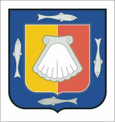
Baja California Norte: The Coast of Arms: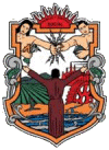
Baja California Sur: The Coast of Arms: |
|
|
The mountains and valley of Baja California have be very rarely visited by archaeologists and is still more or less ignored. Mexico is so rich in archaeological ruins that most investigations are conducted on the mainland. This does not mean there is nothing to note on the peninsula.
Evidence of the native people is found throughout the peninsula. Along the coasts are numerous clamshell middens. Middens are like garbage dumps. The natives would harvest clams for food, then place the shells in one area. As more shells were deposited the middens would grow. These piles also tell the story of the people. At the bottom of the middens archeologists find the largest clamshells. As time goes on, the people harvest more and more clams, depositing smaller and smaller shells on the midden, until the supply of clams dwindled. The people would then move to a new spot and start the process over. The most dramatic evidence that the native people left behind are the dramatic cave painting found in the mountainous areas of the peninsula. Most of the paintings are found in deep, nearly inaccessible arroyos (canyons). This treasury of prehistoric paintings is likely the most distinctive rock art in North America. Many of the caves contain large colorful murals of figures, spirits and animals, so large that they are actually larger than life in size. The character of the paintings cause many people to compare them to the Paleolithic cave paintings found in Europe. So impressive are these paintings that in 1993 UNESCO included them on The World Heritage List. Trekking to the caves’ locations will be one of the Adventures undertaken by ALF’s Explorers. At more than two hundred sites scattered across the Baja peninsula the ancient Indians left rock art ranging from simple petroglyphs pecked on exposed rocks to enormous murals painted on the walls and ceilings of rock shelters and caves. Some of murals contain figures and animals painted life-size or larger. In fact, some are so large in scale or so far off the ground that legends insist that the artists were a race of giants. The most spectacular of the murals are found in the canyons of the Sierra de San Francisco and the Sierra de Guadalupe. Roughly, this covers the mountainous regions both north and south of the town of San Ignacio. The murals usually depict human figures, deer, mountain sheep and rabbits. Occasionally there will be depictions of other animals, birds and even sea mammals. The human figures are usually angular and highly stylized. Many figures are painted in two colors, split either vertically or horizontally. This technique is commonly referred to as "bicolor". Another characteristic of the murals is referred to as "overpainting". This is where the figures have been repainted over and over again. The result is almost a clashing of figures. This effect has been found at other rock art sites around the world. Perhaps shamans come to these sites ask for assistance for their tribe. One thought is that the paintings were intended to be magical and perhaps to enhance the success of a hunt. The true reasons may never be know. However, these murals required great expenditures of time. Paints and pigments need to be made, travel to the remote sites had to be accomplished and ladders had to be built to paint the ceilings. Obviously the designs were produced for important reasons. A number of factors quite beyond the actions of the Painters helped to hide and guard their secrets. Rugged topography has been the greatest single deterrent to anyone attempting to enter and know the Painters' realm. Although the area most involved is no more than 300 or 400 square miles, it is a maze of deep-cut watercourses with towering walls. The terrain is difficult to learn or to find one's way through; any part of it is physically demanding to traverse. Distance in air miles cannot serve as a measure of the difficulties; it does no good to think of this sierra as 35 miles long unless you plan to fly over it. On the ground, trails are forced into tortured horizontal and vertical courses which multiply the miles and tax the muscles of men and beasts of burden. For some photos of the cave paintings be sure to check the Baja Photo Page and the Great Mural Paintings of Baja website. Follow this link to the Missions of |
|
People and |
Indigenous People
In 1697, when the Spanish arrived, there were about 50,000 native people living in Baja California. Of these people, about 80% of them were wiped out by diseases brought by the Spaniards in the 1700’s. Of the original tribes, only the Paipai and the Kumeyaay still exist. The Paipai and the Kumeyaay, together numbering about 700, struggle to survive in communities such as San Jose de la Zorra, 40 miles southeast of Tijuana, Santa Catarina in the Sierra Juarez Mountains and San Isidoro near the Trinidad Valley. They make their living by raising livestock and crops and by selling handicrafts such as willow baskets and pottery. They still live traditionally, harvesting the natural resources such as yucca, honey and pine nuts to provide what they need. But changes may be coming their way. Tribal leaders, anxious to find new sources of income, have partnered with the U.S. Environmental Protection Agency and San Diego State University to begin cataloging commercially valuable medicinal plants. Researchers using a GPS plot areas of specific plant growth and send the coordinates to Ensenada where it is entered on a computer. With help from the Autonomous University of Baja California, the data is combined with existing NASA satellite images to form a three-dimensional view of the 170,000 acre territory. Funding for this project is provided by the EPA and is part of a larger initiative to help U.S.-Mexican border tribes improve their environment through new technology. The official language spoken in Baja is Spanish, however indigenous languages are also spoken by the Paipai, Tipai and Cucapah people in northern Baja. The population of the State of Baja California (northern Baja) is 2.5 million people. The population for the southern half, Baja Sur is 420,000. These figures come form the 2000 Census although it is believed that many people who live in rural areas may not have been counted. Overall, the peninsula is believed to be home to approximately 3 million people. |
|
The dominant religion in Baja is Roman Catholicism, however there are small percentages of Protestant, Jewish and Muslim.
Religion and belief in the supernatural are powerful influences in Mexico. They are reflected throughout the country, from the ancient pyramids and art to the cathedrals built by the Spanish. To the ancient people in Mexico the world was a scary place full of evil. Their lives were at the mercy of their gods. The cycles of day and night, fall and spring and rain or drought frightened the people. The battles fought between the Indians and the Spaniards were more than just a war between people. They were battles between gods. When the Spaniards won, the priests were quick to seize on this significance in their attempts to convert the Indians to Christianity. However, it was easier to get the Indians to convert to the new religion than it was to have them give up their old ways. The Indians did not want to completely give up their gods. So in an effort to placate them the priests adapted traditional beliefs into the worship of local patron saints. They also encouraged the Indians to identify the Catholic saints with their own indigenous gods. As a result, Mexican Catholicism today embraces many different practices. |
|
|
|
| Flora and Fauna |
The Mexican people and their government have taken strides towards the protection their varied natural resources. Many parks, reserves and protected areas can now be found throughout the country. Read all about the fascinating Vizcaino Biosphere. In addition, several locations have been named UNESCO World Heritage Sites. Flora (Plants) Botanists have classified the world’s vegetation into what is considered to be easily recognizable plant communities. Baja California is thought to contain eight plant communities within its boundaries. These eight communities can be further grouped into three main regions: The California Region, The Sonoran Desert and The Cape Region. There are 125 plant species in Baja California that grow naturally nowhere else in the world. The California Region is not unique to Baja, but rather is a continuation of the vegetation found to the north. It contains chaparral in the lowlands, with pine and other conifer trees in the higher elevation. The Sonoran Desert Region covers nearly two-thirds of the Baja peninsula. In the central part of the peninsula is where we can find Baja’s most interesting plants. There are many types of cacti and succulents, and then there are the strange cirio, the elephant tree, and the cardon among others. The Cape Region contains two types of flora. The Arid Tropical Forest contains many plants from the Sonoran Desert, however these plans grow more densely packed due to the availability of more moisture. There are also low spreading trees. The other is the Oak-Pinyon (Piñion) Woodland is found high in the southern mountains. These mountains receive high rainfall from tropical storms. Some of the more common desert plants are:
Be sure to check our Plant Page, as we will be posting photos of many of the plants that we find. You can also check out the web sites at Ocean Oasis and The Baja Desert for detailed descriptions and photos of plants and animals found in the Baja deserts. For a more detailed review of the plants in the Baja Peninsula take a look at the Baja California Plant Field Guide by Norman Roberts. Over 400 plants are discussed and there are 285 color photographs of the various plants. Fauna (Wildlife) In addition to the many insects and reptiles that live in the Baja desert, many of the mammals are the same that are found in the southern deserts of the United States. There are coyote, gray fox, raccoon and even bobcat. However the chances of seeing one of these animals is very low as they are active primarily at night. Be sure to check out the web sites at Ocean Oasis or Desert Ecology, or its mirror site for details and photos of animals found in the Nbrrth American deserts, including the Baja Region. Some common large birds are the:
Many North American water birds migrate to the Baja California coastlines during the winter months. Baja California is nearly surrounded by water and has two distinct shorelines. The shorelines follow The Pacific Ocean and the Sea of Cortez. With so much coastline, Baja have a wealth of marine mammals. You can find California Sea Lions, elephant seals, finback whales, guadalupe fur seals, humpback whales, harbor seals, bottle-nosed dolphins and the California Gray Whale. The California Gray Whale is one of the main study topics of this expedition. Please read the special pages devoted to the California Gray Whale. Follow this link. |
|
|
|
| Turtles |
Of the five species of sea turtles that are known to visit Mexican beaches only two nest on the beaches of Baja, both in the area around Los Cabos. These are the Olive Ridley (Lepidochelys olivacea) and the Loggerhead (Caretta caretta). Look at these photos of the sea turtles species.
Olive Ridley turtles or Golfinas, begin nesting on our beaches in June. The Golfina, which feeds mostly on shrimp, jellyfish, snails and algae, can grow to be 26 inches long and weigh up to 90 lbs. It's primary nesting season is from June to December. The Leatherback or Laud turtle begins its' nesting season in Nov.-Feb. It is the largest of all marine turtles, growing up to 70 inches in length, and weighing up to 1,300 lbs. Its' favorite food is jellyfish, and the Leatherback has been known to dive up to 1 kilometer in depth in search of food Turtles usually lay their eggs on the beach where they were born, sometimes traveling many miles to return. They come ashore at night, dig a hole and deposit up to 200 eggs into it. The hole is then covered and the mother turtle returns to the sea. Six to ten weeks later the baby turtles hatch, digging their way out of the sand and beginning their dangerous journey to the ocean. Obstacles along the way include man, birds, animals and disorientation from man-made light sources. Although it is a crime in Mexico to kill turtles or disturb their nests, the demise of turtle populations continues. There are many factors contributing to the decline in sea turtle populations: pollution, hunting for meat and shells, accidental capture and drowning in fishing nets, collection of eggs for sale by local residents, motorized vehicle use on nesting site beaches, development, boat traffic, natural predation and trade in turtle products. Worldwide conservation efforts are helping but turtles are still in danger. For additional information check the links on the Baja Resources Page. |
|
|
|
|
The migration of the California Gray Whale is one of the most amazing animal behaviors on record. Every winter, beginning in mid-October, Gray whales (Eschrichtius robustus) migrate south from the Bering Sea to the warm lagoons of Baja California (6,000 miles). Breeding along the way, they arrive at the lagoons in December and January and it is here that they give birth to their young. When the calves have grown big enough for the trip home the whales start heading north again from February to May.
There are three major breeding grounds in Baja: Laguna Ojo de Liebre (once known as Scammon’s Lagoon, see below), Laguna de San Ignacio and Bahia Magdalena. Laguna Ojo de Liebre is also the home to the Parque Natural de la Ballena Gris, a national park. Gray whales are baleen whales. This term refers to the bristled plates that hang downward on either side of their upper jaws. These bristles act as a sieve to filter food out of the water. Their upper jaws can expand when taking in large amounts of water and when the water is forced through the bristles, small invertebrates are left behind and eaten. An adult gray whale can eat approximately 2,600 lbs (1,200kg) of these small crustaceans. When migrating and calving however, the grays eat very little. Gray whales are mottled gray in color. They are covered in barnacles and usually have scrapes and scars from feeding along the bottom and from encounters with their only water-borne enemy, the Killer Whale. Gray whales have no dorsal fin but have a low hump followed by 9-12 knobs. The flippers are large and paddle-shaped and the tail very broad, its width equaling almost 25% of the body length. Gray whales are slow swimmers, averaging 3-5 mph (5-8 kph). When traveling, the make shallow dives of 4-5 minutes and then surface to blow 3 or 4 times. Grays also like to breach (leaping out of the water) and spyhop (raising their heads out of the water). These behaviors are not understood but may have to do with breeding or navigation. In 1857, an American Whaling captain named Charles Melville Scammon heard about the whales’ migration to Baja. Following a pod of whales into a small lagoon, he determined that the traditional harpooning wouldn’t work to kill them. He devised a new method and in the small confines of the lagoons, was able to slaughter hundreds of whales a year, selling their oil and blubber for great profit. By the 1930’s, nearly all the gray whales had been eliminated. It wasn’t until 1972 when the U.S. government passed the Marine Mammal Protection Act that the gray whale began a comeback. Now, thirty years later, the comeback of the gray whale is considered one of the greatest successes of the environmental movement. Be sure to check the Gray Whale Fact Sheet and these great Gray Whale Photos. |
|
Contact us for information regarding sponsorship opportunities.
Join the Virtual Classroom. Complete the free registration form for your classroom today. Support the expeditions. Your donation will help to continue the research, documentation and Virtual Classroom web site presentation of these wonderful cultures and experiences to the broadest possible audience. To find out how you can help, please follow this link to our Helping Hand page. Thank you, now it's time to explore! |
|
Home Welcome to Baja The Outback Journal |
Sources: Baja California, Lonely Planet Publications, The Magnificent Peninsula by Jack Williams, Exploring Baja By RV, Peterson, The Cave Paintings of Baja California by Harry Crosby
Kim and Don Greene, Authors; publication date January 20, 2002