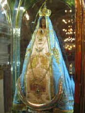
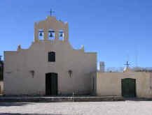
| This morning we visited the center of Catamarca and the Catedral Basilica de Nuestra Senora del Valle that shelters the the Virgen de Valle, an image that apparently appeared in a grotto several kilometers out of town. The actual image appears to have been a statue also, and a simple one at that. The current statue has been beautified with gorgeous clothing and a diamond crown (that she only wears during Easter and Dec. 8th, the patron's day). |
By the way, the Virgen of the Valle is also the National Patron of Tourism, strange?. We regret that we are too early to experience the National Fiesta of the Poncho, yes the poncho, which is also held in Catamarca in July.
We continued our journey north, passing through many small towns and fields of sugar cane. Sugar is the big industry in this region and farms of all sizes grow it and bring it to the processing plants. This creates lots of traffic on the roads with farm machinery, workers and drivers all competing for space and distance. A rather wild ride. There were also camps of itinerate farm workers who travel in large groups with their own harvesting equipment, then hire out to farmers at harvest time.
The next day we headed into Tucuman to fill our propane tank. After a couple of unsuccessful attempts (excuses like: no retail license, no propane), one dealer was finally kind enough to send one of his employees with us to show us the way to a supplier where we were able to get our tank filled and get back on the road toward Tafi del Valle. Along the way, we ran into two other overlanders that we have previously met up with. We spent a couple of hours parked on the side of the road catching up on news and gathering information about the road ahead. Guidebooks are great, but nothing beats up-to-the-minute info.
We headed up into the mountains and into some gorgeous scenery. The road was very winding and steep, but it ran along a river in a deep canyon and the views were spectacular. Some of the other drivers were pretty spectacular too. All of them drive faster than we do, but some of them are just downright maniacal. Especially the tanker truck driver who was barreling down the mountain. We got out of his way, but I'm not sure about the fate of any of the drivers further down the mountain (or the cows that we had just passed, for that matter). We made it safely to the top of the mountains where we found a valley with a beautiful lake. We picked a spot on the shore and spent the rest of the afternoon bird watching.
The next morning we continued watching the birds with the added attraction of watching fishermen in boats catch fish after fish. I don't know what their method was, but it certainly was effective. When the wind came up, we ventured into town to wander around and have a meal of a local specialty, barbecued goat. Yum. Wandering around town we found a shop selling locally made cheese and smoked or cured meat. After tasting some of the cheese, we bought a small round of cheese. The best way to try the local food is to buy or taste what the locals make themselves. Oh yes, the cheese was great!
Sunday morning we woke to a very white world, fog had descended and we could not even see the lake 15 feet from our door. Luckily, within the hour the fog began to lift and we could see that the local fishermen had not be discouraged by the fog as the lake was already full of small boats.
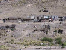
After breakfast we packed up and headed on. We crossed over another mountain pass, one of many that we will be crossing in the next couple of weeks. This pass took us up nearly 11,000 ft (3,384 mts) then down into a more desert region. We passed little hamlets where the homes looked much more like the Andean indigenous homes that we are expecting to see in Bolivia. Adobe homes with mud roofs, and animal corrals of adobe walls and cut brush in a high desert environment. When we stopped for a better look, the locals all stopped what they were doing for a better look at us. Everybody is interested in what the "strangers" do, regardless of who is doing the looking.
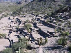
We stopped at one of the best preserved archeological site in all of Argentina, Quilmes. This Andean culture predated the Incas, although they eventually were absorbed into the Inca Empire before being conquered by the Spanish. The ruins consist of large enclosures with dry-stack rock walls filling the valley at the base of the mountains. Being up high allowed the people to see visitors safely from a long ways off. There were even two "forts" located up the mountain where the people could withdraw to better protect themselves. This apparently worked well for nearly 600 years, that is until the Spanish arrived. We spent several hours exploring the ruins and climbing the hills to one of the forts. We found morteros - grinding holes in the granite rock which were used to grind flour and seeds. We even found a couple of spaces that appeared to be for some type of game with areas for spectators to view from up on the walls.
That night we stayed in another municipal campground, this one in the town of Cafayate. Many Argentina towns have city run campgrounds near the city center that cost only a dollar or two per night. Such a great deal.
After breakfast the next day, we did some errands around town, finding a laundromat to wash our clothes, carnecerias to buy our meat and vegetables and an internet cafe to update the website and catch up on emails. We even managed to stop at a couple of wineries for tours of their facilities. At one winery, our tour included a walk through the grape vines, into the cellars where the oak casks are stored and into one of the huge tanks that hold the wine - yes, this one was empty.
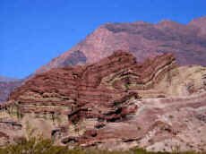
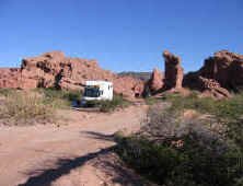
After lunch we headed just north of town into the canyons which were one of the main reasons for our visit. The Quebradas (Canyons) de Cafayate is a region where the colorful sandstone mountains have been eroded into stunning canyons and free-standing monoliths. Engaging the four wheel drive on our Fuso, we were able to drive up the dry washes right up to the base of the hills. We set up camp for the night in the shadow of one of the free standing monuments. In the morning we hiked around the canyon, then drove further along to visit other monuments with names like: the toad, the priest, the devils throat and the amphitheater. The last two were actually slot canyons that we could hike into. The amphitheater ended at the base of a dry waterfall several hundred feet high. The priest was a free standing monument that eroded in such a manner that the sides looked like the folds of a dress or habit. It was really unique.
After driving through the canyon for about 50 km (30 miles) we came out into a wide fertile valley. After noticing the large leafy plants and discussing what they could be, we found several fields where the people where harvesting the plants. They cut them off at the base of the stalk, then hung them on the fences to dry. Tobacco. We have seen this harvested before, but this was the first time we saw the plants hung on the highway fence to dry.
Looking at our map, we saw that we were passing close to a large reservoir and decided to detour by to see if they had any lakeshore camping available. Our instincts proved right, and we set up camp at another municipal campground just a stone's throw from the high water shoreline - of course the water was down so we were actually about 100 yards from the water. After setting up camp in some trees, we looked up and found the trees had other residents, very large spiders hanging in their webs. By large we mean nearly the size of your hand! As long as they stayed in their webs we would get along just fine.
The next morning we took a walk down to the lake and saw a lot of different types of birds. We saw 3 burrowing owls, 2 different types of ibis, 3 types of herons, 2 types of parrots, hawks and lots of little birds.
Continuing on our way, we headed up a canyon to the town of Cachi. The road turned to dirt and was very narrow it spots, but the surface was in good condition and the scenery was gorgeous. The drive took us along a river with mountains soaring on either side. We even had to cross about 7 small streams that crossed the road. The summit peaked at 3,300 meters (10,824 ft). We entered the Parque Nacional de los Cardones, but interestingly, there wasn't a cardon cactus in sight! We think that the park covers a big area, and the entrance is at too high an elevation for the cardons to grow.
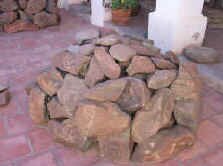
Eventually we reached the town of Cachi. The "town" began as an encomienda which was a land grant from the Spanish that allowed the grantee to enslave the local population to run his ranch. When the encomienda system eventually failed, (no more indians to enslave) the ranch turned into a hacienda which eventually grew into the town of Cachi. We visited the church which had a beautiful vaulted ceiling made of cactus wood and the excellent museum that had displays from the original indigenous population, including large piles of stones with petroglyphs pecked onto them. This was different as most of the glyphs we have seen in other places were done in a panel format on a large wall, not small individual rocks.
While we were at the museum, we saw so many interesting things, we thought we would go out of town and visit one of the archeological sites. We followed the signs out of town, but after leaving the city, there were no more signs. We drove the distance stated on the map we received from the tourist office, but were unable to find the site. We must have gotten lost in the canyons searching for our lost ruins.
Oh well, it was a beautiful drive through the countryside, and oh yes, we did find the beautiful cardons. The roads were so narrow that branches dragged on both sides of the truck and at one point we stop and trim back the branches to get around a truck that was blocking the road. We passed by more adobe homes with adobe roofs, fields of red peppers drying in the sun and saw flocks of burrowing parrots circling overhead. At night we made camp in the cardons and among the (wild?) burros.
